


1. INTRODUCTION
2. PRECISE TRACKING AND IMAGING RADAR
2.1. Survey Results
2.2. Conceptual Design
2.3. Expectations
3. THE STUDY ON COMPREHENSIVE SATELLITE OPERATION PLANS FOR SECURITY PURPOSES
3.1. Space Security
3.2. Current Status of National Security Space Assets
3.3. Technology Necessary to Operate National Satellite for Security Purposes
3.4. Infrastructures Necessary to Operate National Satellites for Security Purposes
3.5. Education and Training for Specialized Workforce
3.6. National Integrated Satellite Operation System
3.7. Laws and Institutions Regarding Space Security and Governance Benchmarking
4. STUDY ON SPACE INFORMATION GIS PLATFORM ESTABLISHMENT FOE SECURITY PURPOSES
4.1. Domestic and Overseas Trends Regarding Space Security GIS Platform Services
4.2. Domestic and Overseas Space Information GIS Platforms
4.3. Design of Infrastructures for a Space Information GIS Platform for Security Purposes
4.4. Platform Compatibility Among Private Sectors and Public Agencies and Plans for Its Comprehensive Operation
5. CONCLUSION
1. INTRODUCTION
Space security means securing laws, institutions, and activities for human activities in the universe and using technologies that make them possible. Space security is a new area of national security that is separate from traditional national security. In the conventional scope of national security, laws and institutions have been established to cope with all events that occur in territories, including the Earth. Still, it is necessary to define a new concept of response in the universe as it is a non-traditional space, different from the Earth’s and without the influence of the Earth’s terrestrial gravity.
As of the end of 2023, the National Satellite Operation and Application Center is operating 8 satellites, including KOMPSAT Satellites, CAS-500 satellites, GEO-KOMPSAT Satellite, and the Korea Pathfinder Lunar Orbiter (KPLO). Nineteen satellites are being developed, including 3 KOMPSAT Satellites, 4 CAS-500 satellites, the GEO-KOMPSAT Satellite, and Nano-satellite constellations. It is estimated that by 2031, various domestic institutions and industrial entities will have completed the development of more than 140 satellites. Once they are launched, these satellites will be operated by the National Satellite Center.
As to the primary direction of space security asset advancement, the following quantitative developments are expected: satellites, ground antenna, mission operation center, satellite information big data center, and radar-based space-monitoring assets. The following qualitative actions are likely: cloud service, automation, platform service, big data satellite information, AI, the convergence of observation, navigation, communication, etc. In addition, it seeks to manage space assets, develop technologies, and establish legal systems for stable and sustainable space activities, including space environment management and space situational awareness for the future space age. To this end, this study presents research regarding technologies, infrastructures, specialized human resources, and legal system governance necessary for national satellites for security purposes. It consists of three sections regarding each subordinate project: the study on how to establish a space object tracking radar system for security purposes, the study on comprehensive satellite operation plans for security purposes, and the study on space information distribution plans related to security.
As to the study on how to establish a space object tracking radar system for security purposes, the performance and functions of the German Fraunhofer Tracking and Imaging Radar (TIRA) and US MIT Lincoln Laboratory (HUSIR, Haystack Ultrawideband Satellite Imaging Radar) were researched and analyzed. In addition, characteristics of precise tracking image radars and those of phased array radars were comparatively examined. The distribution and characteristics of space objects adjacent to national space assets were analyzed, and the essential functions, standards, and performance of radar systems were presented. Based on the above information, the target performance for precisely tracking parabolic radar establishment is derived. Optimal candidate sites that have been selected are suggested in consideration of R&D plans, security issues, and environmental concerns in each area.
The study on comprehensive satellite operation plans for security purposes examines and analyzes the conditions for stable operation preparation and the dangerous situations of national satellites developed according to a public institution plan for satellite development. As satellite development has become more common among public institutions and private businesses, in addition to the Korea Aerospace Research Institute, it is necessary to specify the legal basis for transferring satellite operation duties and responsibilities for technological operation and performance. It is also essential to define the basic details of the technological and operational performance so that the process of satellites developed under the supervision of a private business or public institution is transferred to a dedicated organization for satellite operation. In addition, this study states the roles of developers and operators for the regular operation of multiple satellites, satellite breakdowns, and satellite performance management, as well as plans for operation and configuration management.
Based on the research on establishing and utilizing existing satellite information platforms at home and abroad, this study examines demands and needs regarding space information GIS platforms for security purposes. Based on the collected and analyzed data, target models are established to address current issues and achieve business goals. Strategies and concepts for establishing a space information GIS platform for security are also designed. Comprehensive operation plans are suggested based on the current status and platforms of satellites at home and abroad for the complete operation of private and public satellite information venues. The current status of private and public satellite information interfaces (API, etc.) and system interlinking methods also will be discussed. Platform operation plans are derived in connection with space information platforms for security purposes and infrastructures for the satellite image system operation of the National Satellite Center (facilities, systems, networks, computer security, etc.).
2. PRECISE TRACKING AND IMAGING RADAR
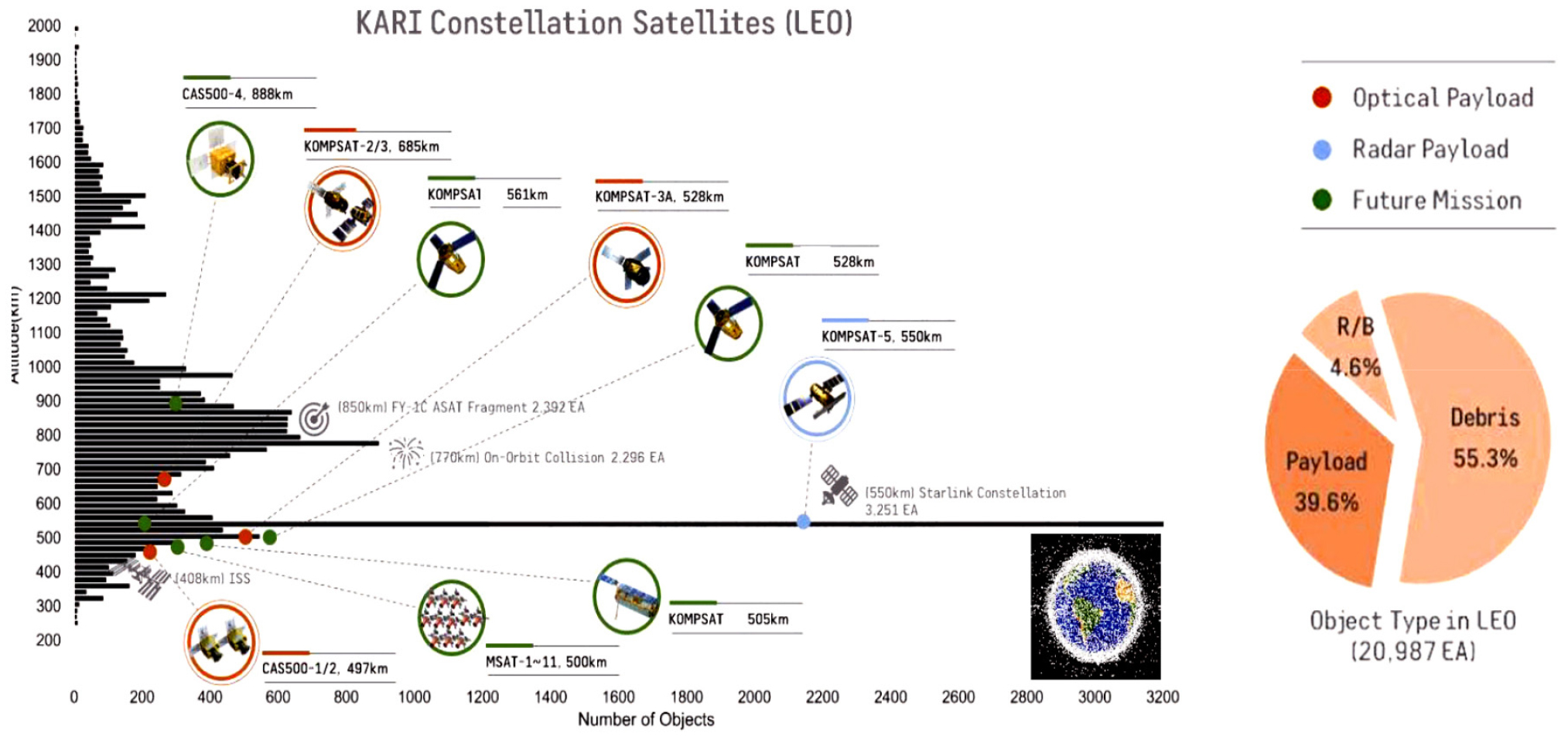
The increasing number of space objects, including satellites with mega-constellations, rocket bodies, and space debris in Earth’s orbit, represents a significant challenge for safe space operations. Fig. 1 depicts the number of objects in the Low Earth Orbit with respect to their altitude. The Y-axis is altitude, and the X-axis is the number of things. Satellites from KARI are also added in the circle. There are already a lot of space objects. The problem is space debris, which is more than 55%, and remained as uncontrolled. This is why Space Situational Awareness (SSA) and Space Traffic Management (STM) pay considerable attention to ensuring flight safety and mitigating collision risk for the entire cycle of space systems, covering on-orbit collision avoidance and end-of-mission disposal. SSA involves monitoring and cataloging space objects, such as satellites and space debris orbiting the Earth. This point is crucial for collision avoidance and identifying potential threats to space assets. Ground-based SSA data sources can be categorized into the following groups: optical camera, RADAR, passive Radio Frequency (RF), laser, etc. They have pros and cons regarding tracking capability, conditions, and operations. This paper reviews parabolic-type RADAR for precise tracking and imaging against space objects.
2.1. Survey Results
2.1.1. Haystack Ultrawideband Satellite Imaging Radar (HUSIR)
The HUSIR represents a significant advancement in space surveillance technology, primarily designed to track and characterize space debris and satellites within Earth’s orbit thoroughly. As an integral component of the space situational awareness infrastructure, HUSIR employs cutting-edge radar technology to enhance the detection, tracking, and imaging of objects across a wide range of orbital regimes, including Low Earth Orbit (LEO), Medium Earth Orbit (MEO), and Geostationary Orbit (GEO).
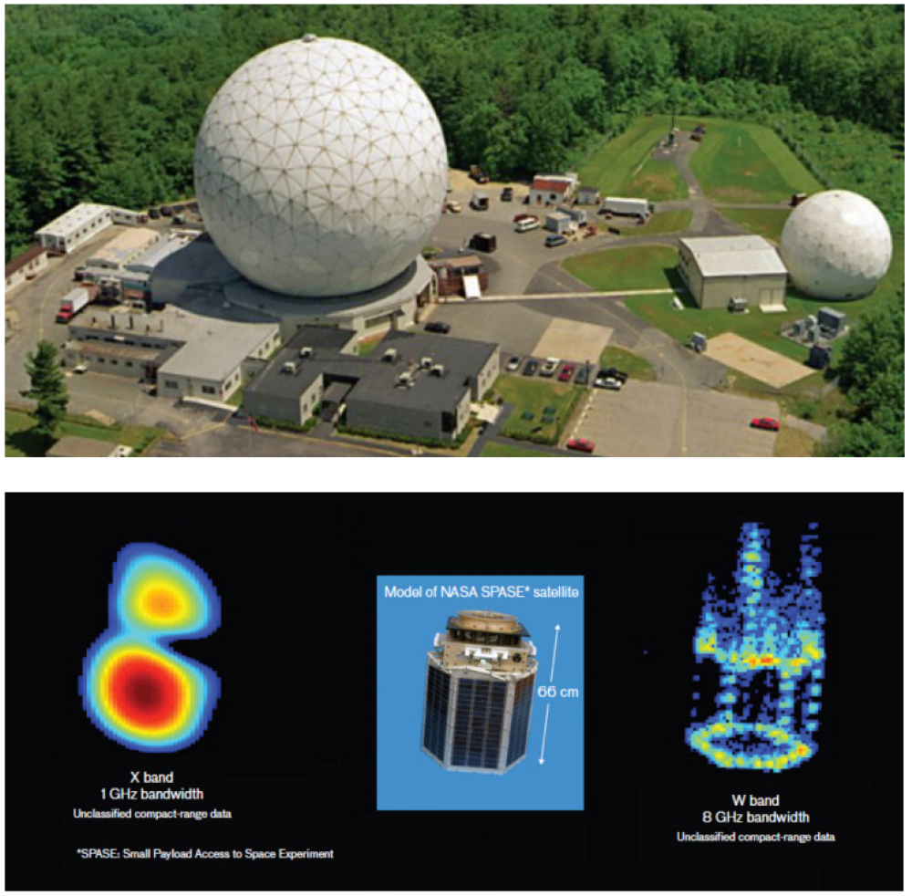
In 2014, the MIT Lincoln Laboratory’s Long-Range Imaging Radar was upgraded, resulting in the construction of the HUSIR by 2022, which became NASA’s primary radar for acquiring the most space object data (Fig. 2). The HUSIR is utilized within the United States space surveillance network (SSN). According to the 2023 Inter-Agency Space Debris Coordination Committee (IADC) WG1 status report, the HUSIR was operated for 420 hours in 2022. Utilizing a 120-foot (approximately 36 meters) parabolic reflector, this radar currently offers the highest resolution among the radars in the US SSN and primarily identifies and characterizes space objects. It employs X-band and W-band to track space objects and acquire imagery. When using the X-band, it can observe space objects as small as 6 mm at a distance of 1000km with an elevation angle of 75° in the eastward direction and detect objects approximately 3 cm in size with an elevation angle of 10° in the westward movement. The Inverse Synthetic Aperture Radar (ISAR) image range resolution is within 3cm, enabling the acquisition of images of objects smaller than 1 meter with 8GHz bandwidth.
2.1.2. Tracking and Imaging Radar (TIRA)
The TIRA system represents a cornerstone in space surveillance, offering unparalleled capabilities for tracking and imaging space objects. Operated by the Fraunhofer Institute for High-Frequency Physics and Radar Techniques FHR in Germany, TIRA plays a pivotal role in supporting space situational awareness by providing detailed observations of satellites and space debris. Constructed in the 1970s and consistently upgraded since then, this radar remains the primary radar of the European Space Agency (ESA) [2].
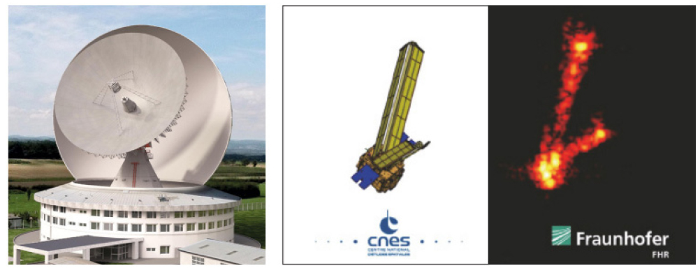
It utilizes a 34-meter parabolic reflector to measure the range, range rate, azimuth angle, elevation angle, and Radar Cross Section (RCS) of space objects, as well as to acquire radar images using ISAR technology (Fig. 3). The radar operates in the L-band for tracking space objects and the Ku-band for high-resolution imaging. As a mono-static radar, it can detect objects as small as 2 cm at a distance of 1000 km, and when used as a bi-static radar with a 100 m parabolic antenna, it can detect objects as small as 0.9 cm.
ESA has utilized this radar for beam-park campaigns to monitor the characteristics of space objects, including recent campaigns since 1993 [3]. TIRA can also observe and characterize satellites and space debris during the re-entry and de-orbiting phases. For example, ISAR images, attitude, and orbit information are obtained for the re-entering Tiangong-1 and re-entering Soyuz 2.1v rocket bodies. It can also obtain current shape/structure and attitude motion information for objects targeted by active debris removal missions. Table 1 shows the specification of TIRA and HUSIR.
TABLE 1.
System specification of TIRA and HUSIR
2.1.3. Parabolic Radar vs. Phased Array Radar
In space object tracking, precision tracking imaging radars and phased array radars are two pivotal technologies, each with unique strengths and operational characteristics. Precise tracking imaging radars are highly specialized systems designed for the detailed imaging and accurate tracking of space objects. These radars excel in high-resolution imaging, enabling the identification and characterization of space debris, satellites, and other things with remarkable detail. The primary mechanism of operation involves a parabolic antenna, focusing electromagnetic waves to achieve superior imaging capability. However, this design necessitates the physical movement of the antenna for tracking, which can limit operational flexibility and response time. On the other hand, Phased Array Radars represent a more versatile technology characterized by their ability to steer the Radar beam electronically without moving the antenna physically. This feature allows for the rapid repositioning of the beam, enhancing the radar’s ability to track multiple objects simultaneously across different sky sectors. While phased array systems offer significant operational flexibility and faster tracking capabilities, they may not match the imaging resolution of precision tracking imaging radars. Furthermore, the complexity of phased array systems is inherently higher due to the need for numerous transmit/receive modules and sophisticated electronic control mechanisms. Table 2 summarizes the difference between precise tracking images and phased array radar.
TABLE 2.
Difference between precise tracking image radar and phased array radar
2.2. Conceptual Design
In this section, we propose the target performance of radar, analyze the target performance feasibility analysis, and suggest a system architecture and development strategy (Table 3).
TABLE 3.
Target performance
2.2.1. Target Performance
- Precision Tracking Mode: Detection of spherical targets of 10 cm diameter @ 1,500 Km
- Imaging Mode: Detection of spherical targets of 10 cm diameter @ 1,500 Km / High-resolution imaging of 10 cm class targets.
2.2.2. Target performance feasibility analysis
For objects of 10cm class, a tracking range of 1,500 km enables the tracking of approximately 91% of all things in Low Earth Orbit. There are 198 objects within this altitude range from 1,500 to 2,500 km. Among 50 Operational Objects, 46 are Globalstar civilian communication satellites (no new launches since 2007), and the remaining are aging satellites. In conclusion, the proportion of hazardous objects exceeding a distance of 1,500 km is nearly zero, and the trend of recent launches is concentrated in orbits below 600 km altitude rather than above 1,500 km in LEO, suggesting minimal risk of security gaps. Therefore, when capable of tracking spherical targets of 10 cm diameter at a distance of 1,500 km, it is possible to track 91% of interest objects, whether adversary satellites or currently operational satellites, an average of 2.42 times per day, allowing for timely and accurate acquisition of orbital information.
2.2.3. Development Strategy
① Antenna
- Development of antennas for two modes—tracking mode and imaging mode—is necessary
- Specifications for the antenna and antenna drive mechanism
- Technical consultation with overseas experts specializing in similar antenna development (preliminary technical consultation completed)
② High-Power Amplification Device
- Development of Semiconductor Power Amplifier (SSPA) domestically
※Opposed to the traditional High-Power Amplifier (TWT) method, does not use high voltage and improves operational availability
※Application of SSPA modularization allows for operation even with partial module failure due to gradual functional degradation
③ Transmitter/Receiver Devices
- Domestic development applying technology secured through previous radar developments
- High sensitivity/Low noise receiver design and manufacturing technology
- High-speed/High-stability frequency synthesizer design/manufacturing technology: Ulsan-Class I search radars, etc.
- Digital waveform generator design and manufacturing technology: Air Force low-altitude radar, etc.
- Wideband receiver design and manufacturing technology: Satellite SAR, etc.
- Design for miniaturization and lightweight objects using semiconductor filters, MMIC, and multilayer board technology
- Design of low-noise, high-stability radar waveform generation/frequency synthesis modules
- Reviewing the necessity of separating the power supply for transmission/reception to maintain isolation
A strategy to mount the transmitter/receiver devices on the back structure of the parabolic antenna is needed
- Procurement of high-power components for the front-end (Isolator, Limiter)
④ Power Supply Unit
- Domestic development applying technology from local power supply companies
- Installation should be as close as possible to transmit high output power to the antenna part through power lines
2.2.4. Inverse Synthetic Aperture Rada (ISAR)
- Application of radar signal imaging technology by synthesizing radar signals according to the direction of the space object’s movement and combining multiple signals (Fig. 4)
- Site selection considering the surrounding terrain and features

We should consider the surrounding terrain and features to secure the line of sight within the radar radiation area. To analyze the human impact of radar radiation, the power density allowable standards are verified according to the electromagnetic radiation safety standards of the International Commission on Non-Ionizing Radiation Protection (ICNIRP), and a safety zone around the radar is established. Controls and management of human exposure situations for workers and the general public around the installation site are implemented. For example, the German Space Operation Center (GSOC) operates the Weilheim Ground Station, which is equipped with satellite communication antennas and a parabolic radar (9 m Antenna). According to recent news, there are plans to develop a 50-meter W-band radar by 2025, with the installation site being an open area behind a 30-meter multiband antenna (Fig. 5).

2.3. Expectations
The construction and operation of the precise tracking and imaging RADAR can strengthen the safety of national satellite operations and space security by responding to conjunction events promptly and systematically. It can improve the orbital precision of space objects and create independent orbital data concerning other external data sources. This protects space assets efficiently by overcoming the limitations of overseas dependency on orbital information with accuracy and timeliness. With space imaging capabilities, any identification and monitoring of space assets, such as changes in posture and shape of space objects of interest, are possible. In the case of future on-orbit services (in-orbit services), accurate proximity operation tasks can be performed through additional information, such as the rotation and altitude verification of two adjacent space objects.
3. THE STUDY ON COMPREHENSIVE SATELLITE OPERATION PLANS FOR SECURITY PURPOSES
3.1. Space Security
3.1.1. Definition and Importance of Space Security
Space security is securing laws, institutions, and activities for human activities in the universe and using technologies that make them possible. In traditional national security, laws and institutions have already been established for all events occurring within the territories of the Earth. In contrast, it is necessary to define a new concept of response in the universe as it is a non-traditional space, different from the Earth’s and from being under the influence of its terrestrial gravity. As to the importance of space security, the spatial area of space security is the universe, as the aim of this new national security is distinguished from traditional national security. However, space security has significant ripple effects on every space, including land, ocean, and air. Furthermore, the importance of space technology is increasingly emphasized as the most potent means to address human security.
3.1.2. Classification of Space Security Assets
Space security assets may be classified into upstream space security assets (projectile, satellite, space-based space monitoring asset, space-based space security asset) and downstream space security assets (ground station, utilization system, ground-based space monitoring asset, ground-based space security asset). Based on the locations of installation, space security assets may be classified as those of the universe (projectile, satellite, space-based space monitoring asset, space-based space security asset, etc.) and those of the ground (space security assets installed in land, oceans, and the sky, etc.). Based on the applications, they may be classified as those for satellite observation, satellite aviation, satellite communication and space monitoring, and cyber purposes. Based on usage, these assets may be classified as infrastructures (infrastructures for monitoring, aviation, communication, satellite operation, satellite information distribution, satellite information utilization, etc.) and arms (space-oriented arms, inter-space arms, earth-oriented arms). Development and operation entities of such assets include international organizations, intelligence offices of each country, related departments, space institutions, public institutions, enterprises, etc. Tank assets are a type of arms developed and operated by the required military. Thus, their development and operation structures are simple. In contrast, space assets are a sort of infrastructure; thus, development and operation entities may vary.
3.1.3. Development Direction and Future of Space Security Assets
Qualitative development areas include data relay satellites, various constellations, areas of aerial photographs and competition among them, cloud service, automation, platform service, big data satellite information, AI, aviation and communication convergence, etc.
As to their utilization in the universe, space environment management for the entire cycle of each space system (design, development, launching, operation, disposal, etc.) and SSA are required for safe, stable, and sustainable space activities. To this end, related technologies, laws, and institutions need to be developed through space traffic control for the future universe age.
As the importance of space security is increasingly emphasized, reformatory measures and investments in related areas of intelligence and national defense will continue to increase. Significant space security issues may include awareness of space as an area of operation, strengthening of space monitoring capability, strengthening of the space garbage response capability, establishing a space traffic control system, expanding a national space security assurance system, etc.
3.2. Current Status of National Security Space Assets
3.2.1. Current Status of National Satellites
The National Satellite Operation and Application Center currently operates 8 units, including KOMPSAT Satellite Units 3, 3A, and 5, CAS-500 1, Geo_KOMPSAT 1, 2A, and 2B, and the KPLO. Sixty-three units are currently under development, including KOMPSAT Satellite Units 6, 7, and 7A, CAS-500 2, 3, 4, and 5, GK-KOMPSAT 3, Nano satellite constellations, Nano satellite systems, etc. As shown in Table 4, various domestic institutions plan to develop more than 140 national satellites by 2031, and the national satellite operation center of Korea Aerospace Research Institute will operate most of these 140 national satellites.
TABLE 4.
Current status and future of national satellite information
3.2.2. Current status of National Satellite Operation and Application Center Infrastructures
To control and receive data from Geo-KOMPSAT Satellites, the National Satellite Operation and Application Center operates the following antennas: two 9m antennas, one 13 m antenna, and 9 m backup antennas. It operates one 13 m and one 7.3 m antenna to control and receive data from a multi-purpose satellite backup. Regular inspection and maintenance ensure stable control, data transmission, and satellites’ initial, emergency, and routine operation.
Jeju National Satellite Center operates two 9m antenna units to control and receive data from low-orbit satellites and is currently developing 11 antennas. To operate Arirang Satellites, next-generation heavy satellites, ultra-small constellations, etc., it stably operates multiple satellites through its low-orbit comprehensive control tower and functional control tower.
3.2.3. Satellite Operation and Ground Network
For multiple satellites, it also operates Norway Svalbard ground station (78 degrees north latitude, control and data transmission through a rented antenna), German Neustelitz ground station (northern part of Berlin, Germany, image transmission through a rented antenna), Antarctic Sejong ground station (67 degrees south latitude, antennas operated at SJS and KOPRI), Thailand Si Racha ground station (located near the equator, utilized to measure the distance of the geostationary orbit), Micronesia ground station (located near the South Pacific Ocean, antennas installed and operated to control low-orbit satellites), and Yeoju Deep Space ground station (KPLO operated by use of an antenna 30m in diameter).
3.3. Technology Necessary to Operate National Satellite for Security Purposes
3.3.1. Integrated Operation Automation Technology
It is necessary to develop an automated system applicable throughout ground station planning, designing, testing, and verification of satellites for security purposes. A ground station must be developed in connection with the design for satellite planning, designing, testing, and validation. The stability and efficiency may be degraded if the specifications and requirements of the system required for each satellite’s development, launching, and operation differ from those of the method used for testing and verification. To secure the stable operation of multiple satellites, the designing and developing process needs to consider the system’s compatibility. In case of any trouble with the newly developed system, it needs to be developed in a way that does not affect the existing system.
3.3.2. Ground Station Upgrading for Operating Satellites for Security Purposes
To operate satellites for security purposes in an efficient manner, there needs to be a system automated throughout the mission steps, from requests for an imaging plan to the delivery of images. A series of steps need to be automated, including the following: making the plan to prioritize imaging requests from users, making a mission plan or command in consideration of satellite communication times, selecting the optimal antenna, transmitting commands to the satellite, processing and saving received images, and delivering necessary images to the user. In addition, a system to minimize the need to involve operating agents also needs to be developed.
3.3.3. Constellation Efficiency/Stabilization Technology
Developing a satellite operation system that integrates multiple satellites for security is vital. The system must incorporate Arirang Satellites, next-generation heavy satellites, and follow-up satellites to operate smoothly at Jeju National Satellite Center. It is necessary to be able to receive, post-process, store, and distribute satellite status data in an automated manner based on the Pass Plan. For the stability of the satellite operation system and duplexing of the Daejeon and Jeju systems, the command procedure format needs to be unified in the use of the automatic command transmission function. Automatic generation and distribution must be possible by optimizing the communication scheduling program and upgrading the communication schedule distribution system for domestic and overseas antenna systems. For the aerodynamic design, the core engine of aerodynamic functions needs to be modularized, integrated, and automated, including orbit determination, orbit prediction, assistance for initial operation, position determination, orbit coordination, and fuel amount estimation. The system must be designed to save image data in various formats (Bypass/CADU/Level0F) and distribute them promptly. The automatic transmission status monitoring system, synchronized with the NAS system data, needs to be applied for storage space unification and efficient data management so that the Daejeon/Jeju control and operation data are coordinated, and data transmission is performed interactively.
3.3.4. AI Based Satellite Troubleshooting and Analysis Technology
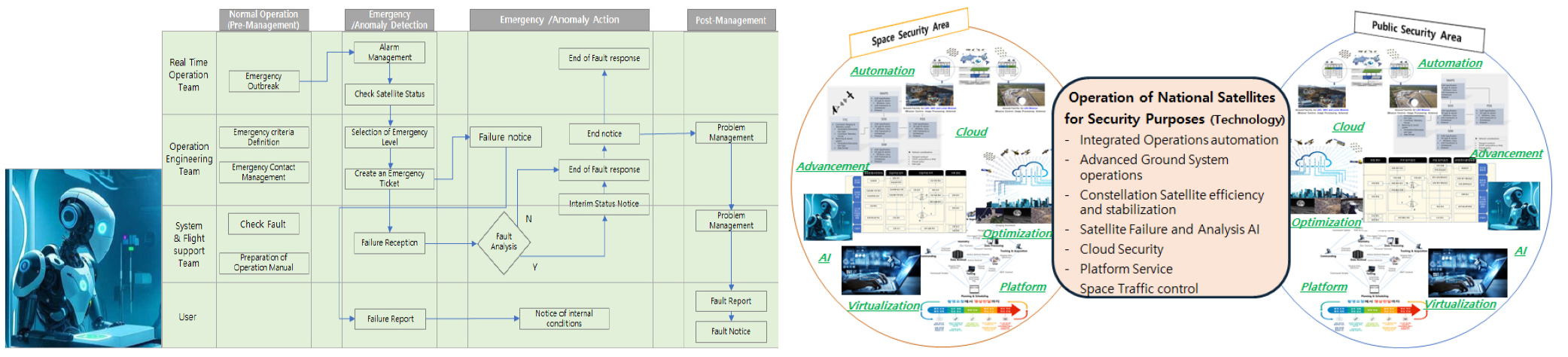
The AI based image management of satellites and ground stations is also vital. Satellite issues and breakdown causes are analyzed based on accumulated satellite development and operation data for years so that AI learns how to cope with them. The satellite status data are analyzed based on what is learned so that any possible satellite breakdown or issue can be detected proactively. As shown in Fig. 6(a), a stable operation basis needs to be established through the telemetry analysis of satellites and long-term trend analysis based on what is learned. If an issue has not been proactively detected regarding the satellite, procedures and measures must be prepared for the follow-up action based on the existing large quantity of data.
3.3.5. Space Traffic Control Technology
It is necessary to secure safe, stable, and sustainable space activities using space assets for security purposes. As space activities are diversified and commercial space development projects are operated by private enterprises (New Space), space objects are rapidly increasing. As a result, space security is emphasized with the increasing need to develop capabilities to monitor, specify, and improve environments and activities in the universe. It is necessary to observe, track, and interpret various activities in the universe for space security and to distinguish space monitoring systems from ground-based ones to track space objects for security purposes in detecting various hostile acts, such as collision with another satellite, hacking, etc.
3.3.6. Separation of the Technology-Based Non-Security Area From the Security Area
Technologies for multiple satellite operations may be classified into security and non-security areas. The system must be configured for the satellite information provision and operation of various satellites for security purposes: Arirang Satellite, next-generation heavy satellite, geostationary orbit satellite, etc. Multiple technologies have to be utilized for satellite operation, including integrated operation system automation, ground system operation advancement, constellations efficiency stabilization, AI-based satellite troubleshooting and analysis, cloud security, platform service, etc. As shown in Fig. 6(b), system functions that have been developed might seem similar, but those for security purposes need to be distinguished from the others. On the other hand, systems for typical applications must be unified to improve efficiency.
3.4. Infrastructures Necessary to Operate National Satellites for Security Purposes
3.4.1. Expansion and Stable Operation of Overseas Ground Stations
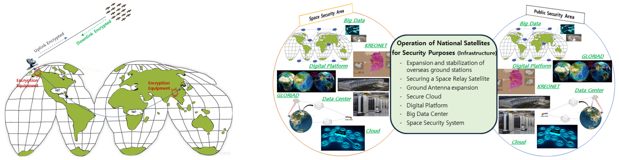
For the stable operation of satellites for security purposes, overseas ground stations play an essential role. Since low-orbit satellites circle the Earth at an altitude of 100 to 1,500 km and a rate of 7km/sec, using a ground station at a position of the mission orbit of the satellite is advantageous for acquiring necessary satellite information anytime, anywhere. While Arirang Satellites are operated, Antarctic Sejong Ground Station (SJS), Micronesia ground station near the South Pacific, Norway Svalbard Ground Station (SGS), and German Neustelitz Station may be utilized to efficiently cope with important issues regarding initial operation and urgent operation, as well as other national issues. Moreover, it is possible to supply large-volume data from multiple satellites promptly. In addition, as shown in Fig. 7(a), overseas ground stations may be operated efficiently by upgrading the security status between a satellite and a ground station or between ground stations.
3.4.2. Space Repeater Satellite Applications
For the stable operation of satellites for security purposes, hand-over and roaming functions of space asset information are necessary. Roaming is a service that interconnects different communication service providers. The benefit of domestic mobile phone use in a foreign country is widely known. The handover functions allows switching from one station to another through a phone while a portable station moves out of a base station onto an adjacent one where the service is provide. Suppose such roaming and handover functions are applied to a space station. In that case, countries owning space assets may communicate with one another wherever they may be, and they can receive essential data for their national security promptly through such data relay service. Data service may be utilized through a global online service provider that uses a low-orbit satellite, such as Starlink in the US and OneWeb in the UK.
3.4.3. Expansion of Ground Antennas
It is necessary to establish multiple ground antenna systems for the optimized operation of various satellites. For satellite communication, satellites in the universe must be connected to a ground station. Antennas of the ground station send radio waves toward a satellite, consuming high power. Antennas of the satellites in the universe then handle received radio waves. Various technologies must be integrated to upgrade antennas, including satellite antenna automation, multiple beam antenna receiving, satellite data utilization, data switching, and weather effect reduction. The Weilheim System in Germany was installed at a position of the high FOV level to improve maintenance efficiency. In addition, the Svalbard ground system of Norway KSAT is located at the north altitude of 78, creating environments where satellites worldwide may be operated. While the National Satellite Operation and Application Center operated the antenna system in Daejeon, multiple antenna systems are also installed at Jeju National Satellite Center to operate various satellites for low-orbit satellites, numerous satellites, and those for security purposes.
3.4.4. Security Cloud
Utilizing cloud service functions is more important than before to efficiently manage information on multiple satellites for security purposes and supply it promptly. Depending on the service range, such systems may be classified as IaaS, which provides infrastructures; PaaS, which provides platforms; and SaaS, which provides software applications. For security purposes, a system for distribution needs to be developed for information on satellites. Thus, SaaS is not applicable. Either IaaS or PaaS may be selected based on the range of management that the cloud service operator is entrusted with. The open Internet is inappropriate since a large volume of information on space assets must be uploaded to the cloud for security purposes. Instead, data uploading and management require a dedicated line and a high-tech research network.
3.4.5. Establishment of a Satellite Big Data Center and Provision of Related Services
In Korea, multiple-satellite and constellation data are expected to increase, including the plan to launch at least 100 ultra-small satellites in the public sector by 2031 (Science and Technology Ministry, 2021, the roadmap for ultra-small satellite development). Collecting and converging information on heterogeneous satellites, such as earth observation satellites and weather/ocean/environment observation satellites, is required. However, problems must be addressed, such as differences in standard terms among satellite information centers and the lack of an organization for integrated data management. Further, it is necessary to smoothly and swiftly collect and process integrated standard data from imaging onwards. Such efforts will contribute to integrating dispersed space data, improving data sharing and utilization through the prompt standard data processing technology, and utilizing satellite information nationally. A center to manage information on satellites for security purposes in an integrated manner needs to be established as a control tower that plays a crucial role in national security and prevents critical security problems.
3.4.6. Separation of the Infrastructure-Based Non-security Area From the Security Area
Infrastructures for multiple satellite operations include the following: satellites for public purposes and systems for satellite operation and information provision, such as overseas ground stations, antenna systems, network systems, and cloud systems (non-security area), as shown in Fig. 7(b). Services for public purposes, such as coping with national disasters, may be made available by systematizing and upgrading information systems for space security, including big data center operation, use of space repeater satellites, etc. While functions of established infrastructures might seem similar, those for security purposes must be distinguished from the others. On the other hand, systems for typical applications must be unified to improve efficiency.
3.5. Education and Training for Specialized Workforce
3.5.1. Education and Management of Advanced Workforce for Satellite Operation
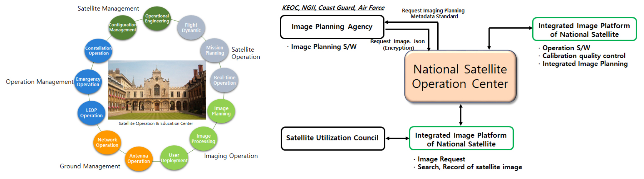
An advanced workforce capable of satellite operation is essential for the stable operation of multiple satellites. As shown in Fig. 8(a), the roles of an advanced workforce include general management of satellite operation, core technology management, emergency control, acquisition of expertise, and development of professional elements in each area. In addition, significant tasks of the advanced workforce mainly include aerodynamic analysis, analysis of telemetry measurements, configuration of mission plans, general management of real-time operation, design and management of system networks, design and management of antenna systems, and satellite operation engineering.
3.5.2. Management of Intermediate-Level Workforce for Satellite Operation
An intermediate-level workforce capable of satellite operation is essential for efficiently operating multiple satellites. Major tasks of the intermediate-level crew include aerodynamic operation, operation of telemetry measurement, process of mission plans, real-time operation, operation of system networks, and operation of antenna systems. For such activities, hands-on training programs and guidelines are required.
3.5.3. Infrastructure Management and Maintenance Team
Ground station infrastructures are essential for the stable operation of space assets for security purposes. The power and network must be secured at all times. As maintenance is necessary for stable satellite communication, the team to operate and manage such infrastructures must be formed. Infrastructures include the following sections: Plants (Building, Utilities, Staff Services, etc.), Maintenance (Mission Control Equipment, Plant Reusable Integrated Items, etc.), and Reusable Integrated Items (Antenna, RF Equipment, Network Equipment, Security Equipment, etc.).
3.6. National Integrated Satellite Operation System
3.6.1. Utilization of a platform for the National Satellite Center
The system for efficient integrated operation of national satellites for security purposes is illustrated in Fig. 8(b). Under the direction of the National Satellite Center, the whole system is operated in systematic cooperation with the imaging plan agency, a national platform for integrated satellite imaging (ultra-small SAR and ultra-small constellation), and a consultative group for satellite utilization. In consideration of the communication with the National Satellite Center, the imaging plan agency makes imaging plans, establishes and operates imaging software programs, secures detailed metadata of the satellite’s location, status, and image quality, and establishes imaging plans and delivers them to the National Satellite Center. The National Satellite Center classifies imaging requests and projects depending on the user level, separating them from satellite control and data transmission duties.
The needs for national satellite operation are varied, including governmental requirements for agricultural management, national security, disaster relief, commercial needs for domestic corporations’ satellite information utilization, etc. There needs to be a system to respond effectively to such various needs. It is necessary to classify imaging requests and plans depending on the user level and separate them from satellite control and data transmission duties. It is necessary to develop standard software for imaging requests and objectives, and access to satellite operation software needs to be secured.
Software, hardware, and infrastructures for satellite information management must be upgraded to supplement or be added to the previous system rather than being newly and separately designed for each satellite development. KSATDB, consultative group systems, ultra-small constellation ground stations, and ultra-small satellite ground stations need to be converged. The future system to manage satellite information of ground stations should make up for and upgrade the existing satellite information management system. Finally, a satellite big data platform must be established for comprehensive satellite information management.
3.6.2. A plan for the efficient operation of the dedicated satellite operation center
The budget and workforce need to be regulated as the number of operated satellites increases. Considering the need to secure technical infrastructures for multiple satellite operations and to manage the security of satellites for security purposes, there needs to be a plan for operation efficiency, such as a budget plan for the dedicated agency for satellite operation. Suppose the expense for satellite information sales is allotted as part of the operating budget for the satellite operation agency, for example. In that case, the nighttime and holiday shifts for satellite operation may be granted the corresponding extra payment. Space agencies dedicated to satellite operations in Italy, Germany, and Japan have their e-GEOS, RESTEC, FGR, and Spaceopal as their subsidies, pursuing the efficient process of satellites and using satellite information in industries.
3.7. Laws and Institutions Regarding Space Security and Governance Benchmarking
3.7.1. Science Technology Development and Traditional Security
Future space security threats will likely be complex and connected to non-military areas. Domestic laws of institutional response systems, including the Space Development Promotion Act, Regulations on Security-Related Space Information Services, Defense Acquisition Program Act, and United Defense Act, have been developed mainly regarding science technology development. Thus, there has been insufficient research and discussion in terms of space security. According to the 2021 Report of the Secure World Foundation, countries with a weapon system in every area of space security are China, Russia, and Europe. Eight countries have established their weapon systems in some regions of space security. Notably, North Korea is regarded as having established a part of its electronic weapon system.
3.7.2. Combination of Space Security and Human Security
The combination of space and human security is expected to grow as essential in maintaining the national identity and system. The UN defines 17 human security areas as follows: poverty, starvation, health and well-being, quality education, gender equality, clean water and public hygiene, clean energy, a decrease of labor and economic growth, industrial innovation and infrastructures, reduction of inequality, sustainable city and local community, responsible consumption and production, climate response, underwater life, ground life, peace and justice, robust system, and partnership. The Group on Earth Observation (GEO), an intergovernmental cooperative organization, declared that to achieve these 17 human security elements, using satellites is essential (Earth Observation in Support of the 2030 Agenda for Sustainable Development, GED, 2017). The EU, US, etc., define human security elements as immigration, climate change, pandemic, environmental pollution, etc. Space security is expected to be further developed in combination with human security.
3.7.3. Space Asset Management and Roles of a National Security Control Tower
From a legal perspective, there is no collaborative system among governmental departments and no control tower for collecting space security information. Additionally, no specific institutional division exists for the performance of integrated defense or space security services. Separate institutions perform similar functions, such as collecting security-related space information. Although the National Intelligence Service has established the institutional foundation for regulating security-related space information services, sharing and distributing space information promptly may be challenging. Regulations on security-related space information services include no specific provision about information collection reports related to space information to the National Intelligence Service by each agency. This suggests the limited, timely sharing of information and intelligence. According to the Government Organization Act, this is because each governmental agency’s dispersed information collection functions are merely limited to security-related space information services regulations. Therefore, it will be more challenging to integrate information/intelligence in real-time with a focus on space security activities and to converge information independently produced by each agency in terms of space power without a dedicated organization for space security. Therefore, measures for each step are required now that no comprehensive and fundamental countermeasure exists. Technology and infrastructure establishment may be on upgrading the Jeju National Satellite Center, establishing a digital platform for satellite information and securing assets for ground-based space monitoring. Establishing an education center for satellite operation is suggested to secure the necessary workforce.
3.7.4. Governance Establishment by Related Laws
As to space security governance, various governmental departments, including private sectors, intelligence agencies, and military agencies, need to agree in active consultation with other individual organizations, such as dedicated centers for satellite operation and assistance.
4. STUDY ON SPACE INFORMATION GIS PLATFORM ESTABLISHMENT FOE SECURITY PURPOSES
4.1. Domestic and Overseas Trends Regarding Space Security GIS Platform Services
4.1.1. Domestic and Overseas Trends Regarding Space Development and Space Information Utilization
As the number of available satellites increases and space technology advances around the globe, efforts are put forth to utilize satellite information in addressing various social issues such as environmental energy resources, food security, disaster relief, etc. Satellite information is the only type of global data that can be collected for an extended period in a near real-time manner. It applies to all areas of human life, including national land, weather, ocean environment, energy, culture, national defense, communication, disaster, etc. The channels of satellite information supply continue to be diversified from the typical image product distribution of direct receiving to subscription-based cloud platform services.
By integrating dispersed space information and applying prompt data processing and analyzing technologies, the level of sharing and utilizing space information can be improved to the extent that it is helpful for social problems as this type of infrastructure system is applied. Notably, a space information platform for security purposes may be established and operated to secure national safety in disasters and national defense.
Applications of space information for security purposes are a crucial area of the satellite information service market. They are now expanding from national defense to social issues such as support for disasters and economic indicator monitoring. In this regard, technologies verified in private sectors, such as ARD, AI/ML, and cloud, are applied, contributing to the broader utilization of space information, as in Table 5.
TABLE 5.
Comparison of characteristics of space information platforms for security purposes and those of public/private space information platforms
4.1.2. Increasing Needs for High-Quality Space Information
The US government has concluded large-scale procurement contracts with its domestic private satellite service enterprises in addition to national satellites of its own intelligence agencies to strengthen GEOINT capabilities, improving its space information procurement ability, as shown in Fig. 9.

4.1.3. AI/ML-Based Economic Indicator Monitoring
The US National Geospatial-Intelligence Agency (hereunder, “NGA”) has conducted the economic indicators monitoring project, including AI and machine learning (AI/ML) algorithms, to support missions to understand economic and trading trends that affect the global economy and military capabilities. The EIM includes commercial satellite data analysis services to improve the US government’s insight into global economic activities related to raw materials, farm products, fuel, vehicles, trends, the enemy’s military abilities, etc. AI/ML algorithms include such functions as object detection, object classification, object segmentation, board area search, pattern detection, area monitoring, and feature mapping.
4.1.4. Cloud-based Integrated GEOINT Service
The NGA has operated the Global Enhanced Geoint Delivery (G-EGD) system to provide map-based unclassified GEOINT information to the Department of Defense, information communities, federal/private agencies, and overseas partners. In 2011, when it was first introduced, the G-EGD system included only Maxar data. Still, recently, it has been integrating five commercial SAR data, including Capella Space, ICEYE, Umbra, and Terra Orbital, to the G-EGD system in addition to the data of Planet and Blacksky.
4.1.5. Platform-Based ARD Service
The NGA participates in the service development for the Analysis Ready Data (ARD) collection and provides Web streaming access interfaces and AI-based change detection tools. Remarkably, the deviation range of less than 10m is considered appropriate among most national defense service users as a CE90 (position precision indicator) scale. When the raw data are measured, the highest-level precision level is less than 5m CE90.
4.1.6. Improvement of the Transmission Speed and Security
When it comes to security data, timeliness is of great importance. Thus, links between optical communication satellites (Optical-ISL) and data relay contracts are often expanded to improve the transmission speed of space information. The security level is also enhanced by introducing blockchain technology that secures the reliability and integrity of collected data.
4.1.7. Diversification of Space Information
Optical images have been utilized for a long time, mainly for change detection and object identification. Radar (SAR), in contrast, has additional advantages in that it can generate images both daytime and nighttime and emphasize structural differences. While the spatial resolution of SWIR and HSI systems is relatively low, they sense more precise spectrum responses between the stomach and plants. MWIR and LWIR systems are capable of sensing and measuring the temperature. Recently, the US AFRL has concluded a 15.5 million dollar contract for HawkEye 360, which is capable of ELINT/RF measurement and electromagnetism detection.
4.1.8. Space Information Supply Method
Subscription-based platform services are now available, improving timeliness compared to traditional image product distribution or direct receiving methods. In addition, satellite image data are combined with in-situ data, being provided with algorithms applicable to various social problems. As such, customized services of better convergence and expertise are developed and made available. As a significant example, the space information platform for security purposes is specialized for the adequate performance of GEOINT services to secure national and public security in such matters as national defense and disaster relief. This space information system’s precision, promptness, and confidentiality are far more advanced than private space information platforms.
4.2. Domestic and Overseas Space Information GIS Platforms
4.2.1. GIS Platform for Space Information Distribution for Security Purposes
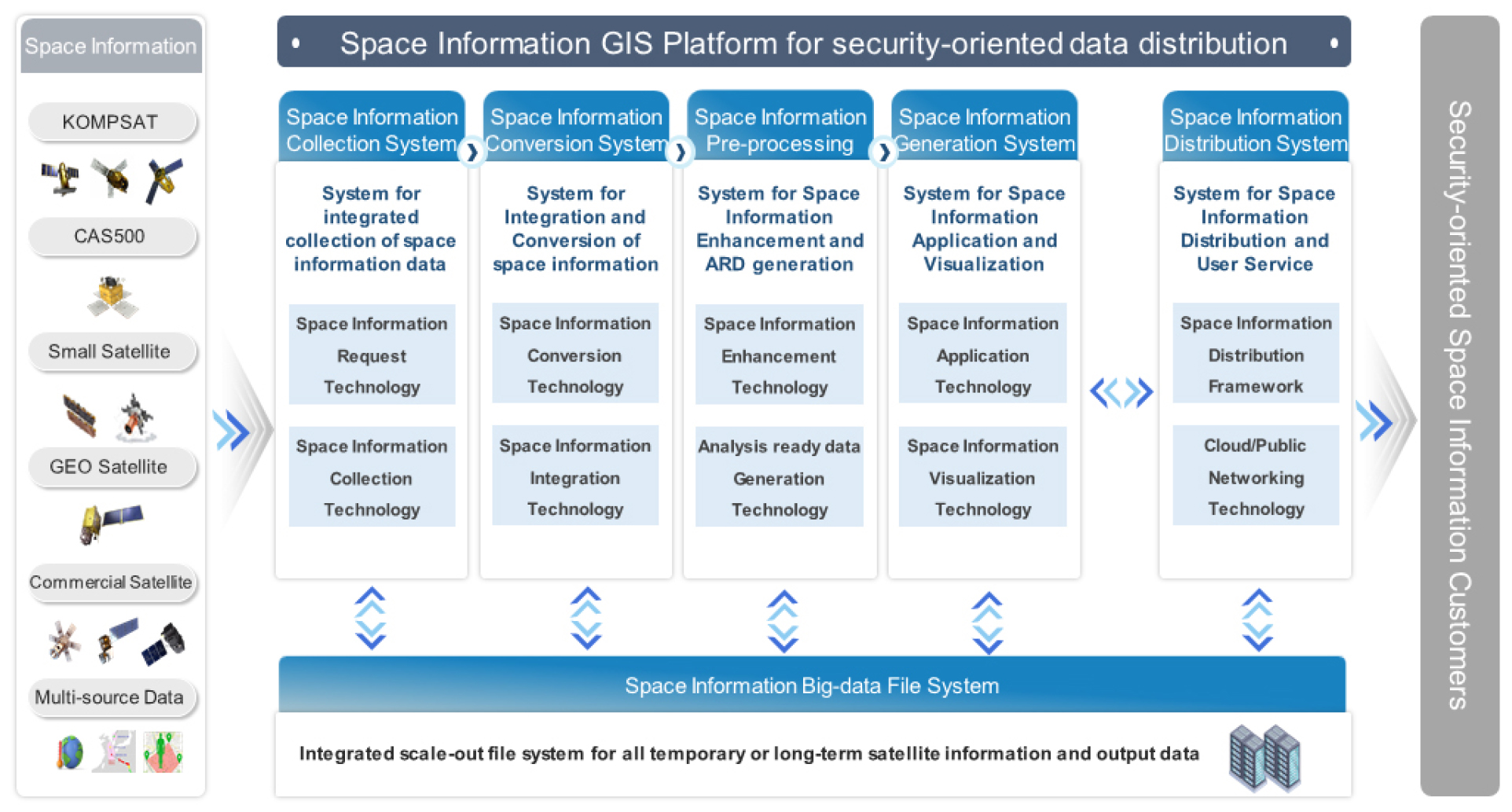
Korea is planning to launch more than 100 ultra-small satellites in the public sector by 2031. As such, information collected by multiple satellites and constellations is expected to increase drastically (Science and Technology Ministry [2021], the roadmap for ultra-small satellite development). Therefore, there is a significant need for a GEOINT process based on information from different kinds of satellites, such as high-resolution earth observation satellites, weather, ocean, and environment satellites, and so forth. However, problems must be addressed, such as differences in standard terms among satellite information centers and the lack of an organization for integrated data management. It is likewise necessary to smoothly and swiftly collect and process integrated standard data from imaging onwards. Such efforts will contribute to integrating dispersed space data, improving data sharing and utilization through the prompt standard data processing technology, and distributing and utilizing satellite information nationally, as shown in Fig. 10.
4.2.2. Space Information Collecting System
The space information collecting system utilizes the following technologies: imaging request/data collection based on the domestic/overseas artificial satellite orbits and position information, imaging request for interested regions based on unstructured data (news, SNS, etc.), data collection in connection with the satellite image system of the National Satellite Center (API/FTP), GEOINT extensive data collection in connection with overseas satellite information (global cooperation, purchase at a cost, etc.) platforms, open extensive data collection from open domestic or overseas satellites (images from Sentinel, Landsat, small satellites, etc.), pack of different types of data, such as drone images, aerial photographs, etc.
4.2.3. Space Information Conversion System
This system utilizes the following technologies: standard image data classification from different satellites, such as optical data (Pan, MS), radar images (SAR), infrared images (SWIR, MWIR, etc.), refining and converting technology based on the characteristics and formats of satellite information and heterogeneous data, storage, management of data from different satellites and other sources, and generation and management of metadata.
4.2.4. Space Information Processing System
This system utilizes the following technologies: automated, precise geometric correction technology based on global reference data, high-precision image registration, pan-sharpening algorithm advancement, image-specific noise modeling, resolution enhancement, quality standardization, CNN/GAN-based diversified ultra-high resolution network, satellite image quality management based on the diversified satellite data standardization technology, K-ARD system development, and significant data generation from global grid-based multi-temporal satellite images.
4.2.5. Space Information Generation System
This system utilizes the following technologies: development of radar-based (SAR) digital topographical altitude data extraction and AI-based index information extraction algorithms, change and SAR-based indicator displacement detection based on the time-series data of extracted index information, extraction of objects of interest, such as aircraft, buildings, ship, and automobiles, detection of object changes based on time-series images, calculation of economic indicators, such as raw material, farm product, fuel, and vehicle traffic, analysis of time-series disposition, analysis of space information big data, GEOINT product packaging, metadata generation, product searching, and visualization-based GEOINT extensive data analysis/application.
4.2.6. System for Integrated Storage of Space Information
This system utilizes the following technologies: on-premise infrastructure environment establishment for storage/management of 100PiB big data, cloud-based infrastructures establishment for GEOINT distribution among users of space information for security purposes, monitoring over infrastructures, such as space information integrated storage system, thermo-hygrostat, UPS, etc., data storage management and status monitoring for integrated space information extensive data storage system, space information big data storage and management, covering data collection, reproduction, duplexing, etc., and security management in consideration of on-premise and cloud networking (network separation solution, etc.). This system is configured as in Fig. 11.

4.2.7. Space Information Distribution System
This system utilizes the following technologies: establishment of WEB/API-based global GEOINT service user environments, user environment establishments of customized GEOINT product services for security purposes, data security management through such means as intrusion protection system (IPS), Web firewall (F/W), etc., development and performance verification of procedures for space information users’ data access authentication and control, network data integrity verification through blockchain means, etc.
4.3. Design of Infrastructures for a Space Information GIS Platform for Security Purposes
4.3.1. Direction for the Establishment of Infrastructures for a Space Information GIS Platform for Security Purposes
It is necessary to introduce a Hadoop cluster-based open-source framework to process a large volume of space data that must be managed temporarily or for a long time in collecting, converting, processing, and creating space information for security purposes. There is also a need for expandable, scale-out file systems where petabyte data can be stored. The latest high-function GPU computing environments are required to converge huge-sized, time-series satellite information and heterogeneous data for the extraction of target objects, such as aircraft, buildings, ships, and automobiles, and the detection of object changes based on time-series images; calculate economic indexes of raw materials, farm products, fuel, and vehicle traffic; and analyze AI-based real-time data, such as time-series disposition, and process-related images. Blockchain technology also needs to be adopted to secure the integrity of GEOINT data from space information GIS platforms for security purposes and to secure the reliability of data protection. To promptly satisfy user needs through the flexible expansion of applications and to facilitate transition even in on-premise and cloud environments, applications need to be developed based on the Micro Service Architecture, whereas a system for container-based application distribution needs to be established.
4.3.2. Expandable Large-Volume File System
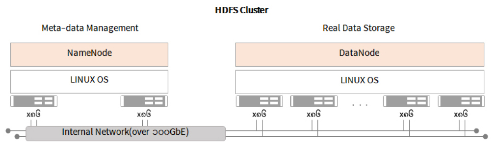
This is a data storage function to retain collected large-volume space information. A general parallel file system must be adopted to distribute large-volume data sets in multiple nodes and process them in parallel. Fig. 12 shows the Hadoop Distributed File System (hereunder, HDFS), a vital component of the Hadoop System that provides means to manage and analyze big data. Since this framework uses parallel processing and decentralized storage systems, they can arrange and save big data, which existing methods cannot store.
4.3.3. Highly Functional Distributed Processing System
It is necessary to secure the latest, highly functional GPU-based computing environments for the following purposes: extraction of target objects, such as automobiles and aircraft, and detection of object changes through time-series analysis and through the convergence of enormous-sized and time-series satellite information, as well as heterogeneous data, real-time data analysis and image processing based on AI model applications, including the calculation of economic indexes, such as raw materials, vehicle traffic, analysis of the time-series disposition, and so forth. Fig. 13 shows SPARK, a fast and flexible open-source framework for large-volume data processing and analysis. It can execute data processing tasks in parallel by utilizing clusters. Exceptionally, to perform tasks in parallel and maximize performance, SPARK clustering may be performed in container and GPU-based environments.

4.3.4. Highly Functional Network System for Security Purposes
A space information network for security purposes requires the connection of data nodes through a high-speed network to secure sufficient data transmission speed and processing performance for large-volume data. As it processes essential data regarding security, such as national defense and disaster relief, data security technologies like network encryption, authentication, and access control, are required. Additionally, space information platforms for security purposes must process large-volume data promptly to produce GEOINT swiftly and accurately. Therefore, scale-up or scale-out expansion needs to be applicable. For the stable provision of services, duplexing and troubleshooting mechanisms need to be adopted, and the network performance should be monitored and maintained.
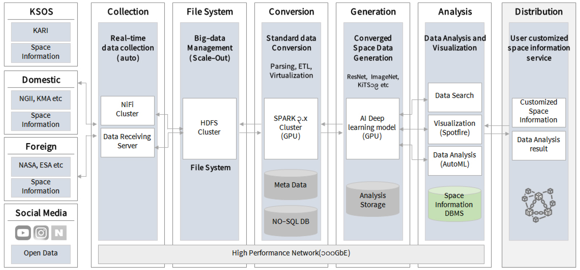
4.3.5. Configuration of a Space Information GIS Platform Infrastructure for Security
A space information platform for security purposes produces and utilizes GEOINT information by collecting and converting satellite images and data from different sources to process and generate such information preliminarily. It must include a general parallel file system for storing and managing large-volume space information, a highly functional distributed processing system for real-time analysis and utilization, and a fast and safe GEOINT-customized network system. Fig. 14 shows the basic configuration.
4.4. Platform Compatibility Among Private Sectors and Public Agencies and Plans for Its Comprehensive Operation
4.4.1. Plans for Comprehensive Operation Based on a Domestic Satellite Platform
Domestic low-orbit satellite control services and standard product manufacturing are expected to be generally managed by the National Satellite Center, with the focus of related agencies on utilizing satellite information. KOMPSAT image data are classified for distribution among consultative groups, public sectors, and commercial sectors by the National Satellite Operation and Application Center per the “Regulations on Distribution and Utilization of Satellite Information” from the Ministry of Science and ICT. For national needs in large-scale disasters, etc., satellite information is free of charge through the dedicated distribution system among consultative groups and agencies that utilize governmental satellite information.
Upon a request for public interests in Korea, orders entered into the distribution system for governmental consultative groups are synchronized and managed through the satellite image system and interface of the National Satellite Center. The National Satellite Center produces and distributes standard products, including three types of optical satellite data and three types of radar images, by processing received satellite data in a standardized manner. In addition, REST-based API services are provided for image searching, archive orders, and new image orders in connection with the automated order search interface.
4.4.2. Plans for Comprehensive Operation Based on an Overseas Satellite Platform
In the case of overseas private satellite operation services, such as Maxar, Airbus D&S, and Planet, various satellite data searching and downloading functions and photograph requesting are provided based on the platform in connection with API-based services. Therefore, it is expected to operate multiple satellites comprehensively using an automated order search interface based on the API-based data collection system.
5. CONCLUSION
Space security is a new area of national security that is separate from traditional national security. Space security means securing laws, institutions, and activities for human activities in the universe and using technologies that make them possible. In the traditional area of national security, laws and institutions have been established to cope with all events that occur in territories, including the Earth. Still, in the universe, it is necessary to define a new concept of response as it is a non-traditional space, different from the Earth, under the influence of the terrestrial gravity of the planet.
As to the primary direction of space security asset advancement, the following quantitative developments are expected: satellites, ground antenna, mission operation center, satellite information big data center, and radar-based space-monitoring assets. The following qualitative actions are likely: cloud service, automation, platform service, big data satellite information, AI, the convergence of observation, navigation, communication, etc. In addition, it is necessary to manage space assets, develop technologies, and establish legal systems for stable and sustainable space activities, including space environment management and situational awareness.
As to the study on how to establish a space object tracking radar system for security purposes, the performance and functions of the German Fraunhofer Tracking and Imaging Radar (TIRA) and US MIT Lincoln Laboratory (Haystack Ultrawideband Satellite Imaging Radar or HUSIR) were researched and analyzed. Based on such research findings, the distribution and characteristics of space objects near national space assets are analyzed. The essential functions, standards, and performance elements of such radar systems are introduced in this paper. In addition, this study suggests the target performance of parabolic radar systems for precise tracking, the R&D plans for each area, and candidate sites for optimal installation for security purposes.
The study on comprehensive satellite operation plans for security purposes examines and analyzes conditions for stable operation preparation and dangerous situations of national satellites, created according to a public institution plan for satellite development. As satellite development is promoted among public agencies and private enterprises in addition to the Korea Aerospace Research Institute, this study discusses the legal basis for the transfer of the duties of satellite operation and responsibilities regarding technical process and performance. This study presents details of the technical and operational performance that need to be defined when the process of satellites developed under the supervision of a private enterprise or public agency is transferred to a dedicated organization for satellite operation. In addition, this study states the roles of developers and operators for the regular operation of multiple satellites, satellite breakdowns, and satellite performance management, as well as plans for operation and configuration management.
Based on the research on establishing and utilizing existing satellite information platforms at home and abroad, this study examines demands and needs regarding space information GIS platforms for security purposes. Based on the collected and analyzed data, target models are established to address current issues and achieve business goals. Strategies and concepts for establishing a space information GIS platform for security are also designed. Comprehensive operation plans are suggested based on the current status and platforms of satellites at home and abroad for the comprehensive operation of private and public satellite information venues. The current status of private and public satellite information interfaces (API, etc.) and system interlinking methods are also stated. Platform operation plans are derived in connection with space information platforms for security purposes and infrastructures for the satellite image system operation of the National Satellite Center (facilities, systems, networks, computer security, etc.).

