


1. INTRODUCTION
2. MATERIALS AND METHODOLOGY
2.1. Investigation of National Satellite Orbits and Specifications
2.2. Investigation of Orbits and Specifications of International Commercial Satellites
2.3. Investigation of National Mission Scheduling Systems
2.4. Investigation of Integrated Multi-Satellite Imaging Systems
2.5. Analysis of the Revisit Period of National and International Satellites over the Korean Peninsula
3. RESULTS AND DISCUSSIONS
3.1. Analysis of Revisit Periods of National Satellites over the Korean Peninsula
3.2. Analysis of Revisit Periods of International Satellites over the Korean Peninsula
4. CONCLUSIONS
1. INTRODUCTION
In recent years, the persistence of global issues such as environmental pollution and natural disasters has underscored the critical importance of Earth observation and surveillance through remote sensing technologies [1]. Information derived from Earth observation and monitoring assumes an indispensable role in mitigating damages caused by environmental pollution, agricultural monitoring, wildfires, and floods, while simultaneously enhancing national security and supporting ship detection efforts. However, aircraft-based observation demonstrates inherent limitations in operational range and sustainability, thus necessitating the development of satellite-based Earth observation and monitoring systems.
Currently, South Korea deploys national satellite assets such as the Korea Multi-Purpose Satellite (KOMPSAT) and the Compact Advanced Satellite 500 (CAS500), which are equipped with Electro- Optical (EO) and Synthetic Aperture Radar (SAR) payloads for observation and monitoring missions [1]. These satellites primarily operate in Sun-Synchronous Orbits (SSO), which maintain a constant angle between the satellite’s orbital plane and the Sun by exploiting perturbations caused by Earth’s gravity. While this orbital characteristic enables efficient satellite operations, it imposes the constraint that satellites pass over the same region at fixed times daily, thereby limiting the revisit frequency.
To address the limitations of SSO, both international and domestic studies have increasingly focused on enhancing revisit frequency through satellite constellation deployment [2] and orbital design [3]. In South Korea, given the relatively small number of satellite constellations compared to other nations, research has been conducted to utilize international satellite data for disaster monitoring and detection. For instance, the Korea Water Resources Corporation(K-Water) has collaborated with Finland’s ICEYE and the United States’ Capella Space to acquire dam imagery in Korea. By leveraging the shorter revisit cycles of small SAR constellations, these collaborations have demonstrated significant contributions to disaster management [4].
Internationally, numerous countries and companies have developed and deployed satellite constellations for commercial services. Planet Labs, based in the United States, operates a constellation comprising more than 180 Dove satellites, enabling continuous and extensive area observation through diverse flight patterns. Finland’s ICEYE constellation, equipped with SAR payloads, provides users with the capability to select resolution levels based on Strip, Spot, and Scan modes. Similarly, Japan’s iQPS is currently implementing plans to operate a 36-satellite SAR constellation, with satellites Izanagi and Izanami already operational [5,6]. These global efforts underscore the advancement of satellite-based Earth observation systems and the vigorous research activity surrounding their development. Notably, whereas traditional Earth observation satellites can capture target regions up to 10 times per day, satellite constellations achieve marked improvements in revisit frequency.
Efficient execution of observation and monitoring missions using satellite constellations necessitates the implementation of robust task scheduling systems. Task scheduling must account for multiple factors including mission objectives, task constraints, resources, and operational limitations [7]. One notable study applied seven key variables, including customer requirements, mission deadlines, financial revenue, urgent scenarios (e.g., disasters or wartime), energy availability, memory capacity, and cloud coverage for optical satellites. These variables were scored and prioritized to determine task execution order. Genetic algorithms, which mimic natural selection and evolution processes, were employed to derive optimal solutions [8]. Other studies have addressed mission scheduling complexities, such as satellite attitude control and observation task prioritization, using Mixed Integer Linear Programming (MILP)[9,10]. MILP-based optimization guarantees global optimal solutions, provided a feasible solution exists [11,12]. Furthermore, MILP has been applied to solve Time Window (TW) problems, which determine the availability of satellite access to target regions [13].
Another study integrated mission scheduling with ground station communication, incorporating visibility constraints, one-to-one communication requirements, mission preparation times, and memory limitations [14].
Beyond mission scheduling, studies have focused on orbital design to increase the revisit frequency of target regions. Research has demonstrated the efficacy of analyzing revisit cycles through the strategic configuration of satellites across different orbital planes [15,16]. Another investigation designed a constellation comprising 20 orbital planes optimized for surveillance of the Korean Peninsula, achieving an average revisit time of less than 30 minutes to enable near-real-time monitoring [17]. Furthermore, accurate attitude control of satellites is essential for precise imaging of target locations. Consequently, researchers have proposed the implementation of a spin-to-spin maneuver, which facilitates the calculation of optimal profiles by substituting angular velocity between each task for the conventionally used rest-to-rest maneuver [18,19,20,21].
Regarding international developments, the escalating importance and utilization of satellite imagery have precipitated a growing demand for more extensive imaging missions [22]. Consequently, studies have been conducted to establish imaging plans by selecting target regions using high-mobility satellites [23]. Multiple instances exist where MILP has been employed to address multiple satellites and numerous constraints. Reference [24] formulated an MILP problem by incorporating constraints such as satellite maneuverability and ground station limitations and utilized Dynamic Programming (DP) to derive optimal solutions. References [25,26] addressed MILP problems by applying constraints on mission start times and satellite maneuverability, solving them through the Branch and Bound (B&B) Algorithm. Similarly, reference [27] considered conditions involving satellite maneuverability and mission priorities, solving the MILP problem using the Genetic Algorithm (GA).
With the rising demand for satellite imagery across applications such as environmental monitoring and disaster response, beyond reconnaissance purposes, the number of customers requiring satellite data has significantly increased. This growing demand has also escalated the volume of imaging tasks, thereby exposing limitations in traditional optimization methods. To overcome these challenges, studies in references [28,29,30,31] have successfully applied reinforcement learning and deep learning techniques to plan large-scale imaging schedules and subsequently compared the results with conventional algorithms.
Additionally, to ensure faster transmission of the vast amounts of imagery obtained through satellite missions, systems for efficient data transmission to ground stations have been explored in reference [32]. However, transmitting large volumes of data to a single ground station may precipitate data bottlenecks. To mitigate this issue, a study on downlink scheduling was conducted in reference [33].
Conversely, post-processing is requisite for the effective utilization of satellite imagery acquired at ground stations. Reference [34] has proposed converting two-dimensional satellite imagery into high- resolution three-dimensional mapping through post-processing techniques. Furthermore, reference [35] analyzed high-resolution coastal imagery obtained via satellite to investigate coral habitats.
This study investigates the potential to increase imaging opportunities over the Korean Peninsula by analyzing both operational and planned national satellites as well as commercially available international satellites. Moreover, we examine algorithms and systems that can be employed when planning imaging tasks with multiple satellites and analyze the limitations of current domestic systems.
Section 2 provides a detailed exposition of the orbital and system specifications of national satellites, the orbital and system specifications of international commercial satellites, the current status and limitations of national imaging planning systems, advanced international cases of integrated heterogeneous satellite imaging systems, and an analysis of access opportunities over the Korean Peninsula. Section 3 calculates and analyzes the access opportunities over the Korean Peninsula using the satellite information and mathematical formulas presented in Section 2, integrating the results for a comprehensive analysis.
2. MATERIALS AND METHODOLOGY
2.1. Investigation of National Satellite Orbits and Specifications
Currently, the Republic of Korea operates a total of 6 Earth observation and surveillance satellites through national agencies. We systematically analyzed the orbital information, payloads, and performance characteristics of the payloads for each satellite. The orbital information was sourced from CelesTrak, with the caveat that orbital elements undergo temporal variations due to perturbation effects; thus, the data represents conditions based on Coordinated Universal Time (UTC) as of June 17, 2024.
To facilitate comparative analysis of the payload performance, we first investigated the types of images captured by satellites. These images are broadly categorized into two types: Panchromatic and Multispectral images. Panchromatic images are generated by image sensors that capture light across the entire range of visible and near-infrared light. These sensors detect electromagnetic waves in the 0.5-0.9 µm band and exhibit higher sensitivity to light, resulting in superior resolution. However, they possess the inherent limitation of not incorporating color information. Multispectral images are obtained through the integration of images from various bands of the visible light region (0.45-0.75 µm) and the near-infrared region (0.76-0.9 µm). While these images facilitate the acquisition of color information, their resolution remains lower compared to panchromatic images.
The Korea Multi-Purpose Satellite-3 (KOMPSAT-3), also known as Arirang Satellite-3, is an Earth observation satellite launched on May 18, 2012, from Japan’s Tanegashima Space Center using the H-IIA rocket. It features a diameter of 2.0 m, a height of 3.0 m, and a mass of 980 kg. Following the successful completion of its official mission period of four years, it has extended its mission lifespan and continues to perform missions to this day. As the first sub-meter high-resolution satellite in South Korea, it has successfully acquired over 1.8 million images through approximately 180,000 observations [36]. KOMPSAT-3 collects images while orbiting the Earth approximately 15 times per day, and the collected image information serves critical functions in analyzing forest degradation following wildfires, detecting changes in urban areas, and facilitating object-based image classification [37]. All processes of satellite development—including the satellite system, payload, body, system assembly, and testing—were developed using domestic technology. The satellite incorporates the Advanced Earth Imaging Sensor System (AEISS), an optical payload for image information collection developed for the first time by the Korea Aerospace Research Institute. Additional details are summarized in Table 1[38].
TABLE 1.
KOMPSAT-3 orbital information and system specifications
The Korea Multi-Purpose Satellite-3A (KOMPSAT-3A), also known as Arirang Satellite-3A, is an Earth observation satellite launched on March 26, 2015, from Russia’s Yasny launch base using the Dnepr launch vehicle. It possesses a diameter of 2.0 m, a height of 3.8 m, and a mass of 1,100 kg. Upon successful completion of its official mission period of four years, it has extended its mission lifespan and continues to execute precise Earth observation missions. The satellite features an improved high- resolution electro-optical camera, the Advanced Earth Imaging Sensor System-A (AEISS-A), and an infrared sensor, both of which represent technological advancements over the AEISS installed on KOMPSAT-3. As the first satellite in South Korea equipped with an infrared sensor, it possesses the capability to obtain observation information regardless of diurnal cycles and weather conditions. Additional specifications are summarized in Table 2[39].
TABLE 2.
KOMPSAT-3A orbital information and system specifications
The Korea Multi-Purpose Satellite-5 (KOMPSAT-5), also known as Arirang Satellite-5, is an Earth observation satellite launched on August 22, 2013, from Russia’s Yasny launch base using the Dnepr launch vehicle. It exhibits a diameter of 2.6 m, a height of 3.9 m, and a mass of 1,315 kg. This platform represents the first satellite in South Korea to be equipped with a Synthetic Aperture Radar (SAR). SAR operates on the principle of emitting microwaves toward ground targets and synthesizing the reflected signals to create images, thereby enabling ground observation regardless of temporal constraints and weather conditions. Currently, KOMPSAT-5 provides four operational modes contingent upon resolution and swath width. Further specifications are summarized in Table 3[40].
TABLE 3.
KOMPSAT-5 orbital information and system specifications
The Compact Advanced Satellite 500-1 (CAS500-1), the first in the next-generation medium satellite series, is an Earth observation satellite launched on March 22, 2021, from the Baikonur Cosmodrome in Kazakhstan. The platform weighs approximately 500 kg and is designed for a mission lifespan exceeding five years. CAS500-1 is equipped with an optical camera capable of observing wavelengths ranging from 0.4 µm to 1.2 µm. Additional details are summarized in Table 4[41].
TABLE 4.
CAS500-1 orbital information and system specifications
The Next-Generation Small Satellite-2 (NEXTSat-2), a next-generation small satellite, was launched on May 25, 2023, using the Nuri rocket. It is configured for a mission lifespan exceeding two years and weighs 180 kg. NEXTSat-2 is equipped with a SAR payload, enabling ground observation regardless of temporal and meteorological conditions. Additional specifications are summarized in Table 5[42].
TABLE 5.
NEXTSat-2 orbital information and system specifications
| Launch Date | 2023. 05. 25 | |
| Orbit | Altitude | 529.3 km |
| Inclination | 97.5° | |
| Type | SSO (Sun Synchronous Orbit) | |
| Payload | SAR (Synthetic Aperture Radar) | |
| Payload Performance | Resolution | 5 m |
| Observation Width | 25 km | |
The New-space Earth Observation Satellite-1 (NEONSAT-1), the first ultra-small satellite in its series, was launched on April 24, 2024. It is equipped with an optical camera for Earth observation. Additional orbital and system specifications are delineated in Table 6[43].
TABLE 6.
NEONSAT-1 orbital information and system specifications
Furthermore, we investigated Earth observation satellites that either await launch or possess the potential for utilization in future integrated imaging plans. As part of the follow-up projects for the Korea Multi-Purpose Satellite (KOMPSAT) series, the launches of KOMPSAT-6, KOMPSAT-7, and KOMPSAT-7A are currently scheduled. KOMPSAT-6 will carry a SAR payload, while KOMPSAT-7 and KOMPSAT-7A will be equipped with Electro-Optical/Infrared (EO/IR) cameras [44].
Regarding the follow-up to the Compact Advanced Satellite 500-1 (CAS500-1), launches of additional Compact Advanced Satellite 500 (CAS500-2 to CAS500-5) have been programmed. Among these platforms, CAS500-2 will perform Earth observation missions analogous to those of CAS500-1 [45].
Finally, regarding the New-space Earth Observation Satellite(NEONSAT), a total of ten follow-on satellites will be developed and launched: five in 2026 and an additional five in 2027. This expansion is designed to significantly reduce the time required for acquiring imagery covering the entire Korean Peninsula [46].
2.2. Investigation of Orbits and Specifications of International Commercial Satellites
Earth observation satellite constellations such as SkySat, ICEYE, Worldview, and GeoEye are currently operated by various commercial entities globally.
The SkySat constellation, operated by Planet Labs in the United States, comprises a group of small Earth observation satellites. A total of 21 satellites were launched between November 21, 2013, and August 18, 2020, with 18 satellites currently operational. Among these platforms, 15 satellites execute missions in Sun-Synchronous Orbit (SSO), while 3 satellites operate in a 53° inclined orbit. These satellites are equipped with optical cameras, whose performance specifications vary according to the individual satellite. Details regarding the SkySat constellation are summarized in Table 7[47]. Note that panchromatic images are designated as Pan and multispectral images are designated as Mul in Table 7.
TABLE 7.
Skysat orbital information and system specifications
The ICEYE-X constellation, operated by the Finnish company ICEYE, represents a commercial Earth observation system that commenced satellite deployment on January 12, 2018. To date, 32 satellites remain operational, all of which perform their missions in Sun-Synchronous Orbit. ICEYE-X satellites are equipped with X-band Synthetic Aperture Radar (SAR), which facilitates continuous observation regardless of temporal or meteorological conditions. This SAR capability effectively compensates for the limitations of domestic satellites, which frequently encounter operational constraints during nighttime or adverse weather conditions. The ICEYE constellation supports five operational modes: Strip, Spot, Scan, SLEA, and Dwell. Further details are provided in Table 8[48].
TABLE 8.
ICEYE-X orbital information and system specifications
The WorldView constellation, operated by Maxar Technologies in the United States, constitutes a high- resolution commercial Earth observation satellite system. Four satellites were launched between 2007 and 2016; however, the mission of WorldView-4 was terminated in January 2019 due to a loss of attitude control, resulting in three satellites currently remaining operational. These satellites capture images with a resolution of at least 0.31 meters, supporting both military and commercial applications. Maxar Technologies has additionally announced plans to operate a new constellation, WorldView Legion, consisting of six satellites capable of achieving a resolution of 0.29 meters. WorldView-1, the first in the series, is equipped with the WV60 optical camera, which supports only panchromatic (black and white) imaging. Its specifications are summarized in Table 9[49]. The second satellite, WorldView-2, features both panchromatic and eight-band multispectral imaging capabilities, with its specifications being detailed in Table 10[50]. WorldView-3, the third satellite, supports 29 spectral bands, enabling detailed material analysis from the captured imagery. Consequently, WorldView-3 imagery has found extensive application in environmental monitoring. Its specifications are summarized in Table 11[51].
TABLE 9.
WorldView-1 orbital information and system specifications
TABLE 10.
WorldView-2 orbital information and system specifications
TABLE 11.
WorldView-3 orbital information and system specifications
The Pleiades Neo constellation, operated by Airbus Defence and Space in Europe, encompasses very high-resolution Earth observation satellites achieving a resolution of 0.3 meters. Currently, two satellites remain operational, with their specifications being detailed in Table 12[52].
TABLE 12.
Pleiades Neo 3, 4 orbital information and system specifications
The Whitney and Acadia series, operated by Capella Space in the United States, are commercial Earth observation satellites. The Whitney series commenced operations with the launch of eight satellites (Capella 4-10) starting on January 24, 2021; however, only two satellites, Capella 9 and 10, remain operational. The Acadia series initiated operations with its first launch on March 16, 2023, and all four satellites launched to date remain operational. Earlier satellites, Denali (2018) and Sequoia (2020), were also part of this program but completed their missions in 2023. Details of the currently operational satellites are summarized in Table 13[53,54].
The Umbra constellation, operated by Umbra Space in the United States, commenced with its first satellite launch on June 30, 2021. Since then, launches have proceeded continuously, with 10 satellites launched to date, of which 5 remain operational. Umbra Space has articulated plans to expand this constellation to a total of 32 satellites. All satellites in the Umbra constellation operate in Sun- Synchronous Orbit (SSO). Further details on the operational satellites are summarized in Table 14[55,56].
TABLE 13.
Capella’s Constellation orbital information and system specifications
TABLE 14.
Umbra’s Constellation orbital information and system specifications
The QPS-SAR series, operated by iQPS in Japan, represents a small SAR satellite constellation. A total of six satellites have been launched, with plans to expand the constellation to 36 satellites. Among the six launched satellites, only three satellites, QPS-SAR 5, 7, and 8, remain operational, as QPS-SAR 3 and 4 experienced launch failures. Two of the operational satellites perform missions in Sun-Synchronous Orbit, while one operates in a 45° inclined orbit. Details of the currently operational satellites are summarized in Table 15[57].
TABLE 15.
QPS-SAR orbital information and system specifications
2.3. Investigation of National Mission Scheduling Systems
As of 2021, four Korea Multi-Purpose Satellites (KOMPSAT) were operational, including KOMPSAT-2, KOMPSAT-3, and KOMPSAT-3A, which are equipped with Electro-Optics (EO) sensors, and KOMPSAT-5, equipped with a Synthetic Aperture Radar (SAR) sensor capable of capturing images regardless of weather conditions or time of day. Although KOMPSAT-2 completed its mission in July 2015 after a successful three-time mission extension since its launch in July 2006, it continues to capture images to satisfy additional image demands and requests.
KOMPSAT satellites generate global imaging and communication plans based on user requests. In this report, a ‘revisit set’ is defined as a group of 2-3 short revisit cycles, and the ‘revisit period’ constitutes the interval between the start of the first revisit in one set and the next. Starting in 2016, a Multi-Satellite Scheduling System (MSS) was planned and developed over 15 months [58]. Initially, the Korea Aerospace Research Institute (KARI) focused on developing a single-satellite scheduling system for KOMPSAT-3. The project was subsequently expanded to include KOMPSAT-3A and KOMPSAT-5, with the objective of automatically optimizing multi-satellite imaging plans.
The completed MSS operates through four stages: filtering the feasible imaging regions, generating strips for target areas, calculating scores for imaging orders, and outputting the final integrated imaging plan.
First, the system identifies areas within the satellite’s orbital range to filter visible imaging requests. Imaging orders are selected based on whether they fall within the imaging coverage of each satellite.
Next, the filtered orders are utilized to generate strips, which divide the feasible imaging regions into distinct target areas to be captured by the satellites.
Following strip generation, the system assigns weights to the filtered orders based on their priority and other constraints. Scores are calculated for each imaging order, and the imaging plan is optimized to maximize the total score while accounting for satellite constraints. These constraints include orbital conditions, conflicts between orders, power consumption, and data storage limitations.
Despite the capabilities of the MSS, several technical and institutional limitations persist.
From a technical perspective, the number of operational national satellites and ground stations remains insufficient. As of 2021, only three satellites were operated within the MSS, whereas six satellites are projected to become operational by 2024. Additionally, there are only six ground stations: four in Jeju Island, one in Germany, and one in the polar region. In contrast, international satellites like ICEYE-X manage approximately 32 satellites, thereby emphasizing the need for either additional national satellites or the adoption of commercial satellites. Furthermore, as the number of satellites and ground stations increases, the complexity of mission scheduling problems grows exponentially. To address this, intelligent automation systems capable of solving complex nonlinear optimization problems must be implemented.
From an institutional perspective, international cooperation and diplomatic considerations constitute significant challenges. Expanding the number of satellites and ground stations necessitates international collaboration. Moreover, to avoid conflicts in imaging or data transmission plans between nations, a strengthened framework for data sharing is imperative. Finally, there exists a need for clear guidelines regarding the scope of satellite image utilization. Currently, satellite orders are categorized into public and commercial groups based on affiliation and purpose. To further stimulate commercial usage, policies such as expanding the scope of accessible data must be implemented.
2.4. Investigation of Integrated Multi-Satellite Imaging Systems
The development of integrated satellite imaging systems has progressed globally to meet the escalating importance of national security, land observation, and climate disaster prediction. These systems incorporate not only satellites operated by individual countries or companies but also heterogeneous satellites to perform coordinated imaging tasks. This section explores advanced international examples of such integrated systems.
Orbit Logic’s CPAW (Collection Planning and Analysis Workstation) represents a software program that creates optimized imaging plans for satellites equipped with Synthetic Aperture Radar (SAR) or optical sensors [59]. CPAW ensures that mission constraints are satisfied while maximizing overall gains. The system simulates physical environments, spacecraft systems, and target requirements, presenting results using mapping tools such as STK (Systems Tool Kit) or Google Earth Pro.
The imaging algorithms employed within CPAW utilize various optimization techniques and calculate gains based on a common performance metric known as the Figure-of-Merit (FOM). The FOM score incorporates factors such as imaging priority, coverage area, cloud interference, resolution, and cost. Once optimized, the imaging plan outputs results in table format or as 2D/3D animations on a map interface.
The CPAW system operates through five primary stages: target definition, ground station communication planning, imaging plan generation, filtering, and final plan output.
During the target definition stage, users can modify targets, such as adding or removing locations, specifying imaging angles, and setting priorities within the satellite’s operational constraints. Target positions can be generated using latitude/longitude coordinates, STK, or Google Earth and can be input in various formats (e.g., KML, SHP).
Ground station communication planning calculates the Time Window (TW) during which satellites can transmit imaging data to ground stations. This calculation incorporates the positions, altitudes, and communication capabilities of both the ground stations and satellites.
The imaging plan generation stage automatically creates plans based on physical constraints and provides various options. Users may specify desired imaging time slots, and the system will generate plans accordingly. Additionally, users can integrate communication-based imaging plans, ensuring that imaging occurs during data transmission windows while considering the sensor’s ability to capture images under both diurnal and nocturnal conditions.
The filtering stage refines the generated plans by analyzing the feasibility of capturing images within specified time windows. Large target areas are divided into strips, whose size and direction depend on imaging constraints, satellite sensor configurations, orbital conditions, and sequencing parameters. The filtering process excludes areas based on factors such as priorities, cloud interference, and Line of Sight (LOS) conditions, thus reducing imaging scope. The remaining prioritized targets are then incorporated into the plan.
For multi-satellite systems, CPAW features an automated processing function called One Button Planning (OBP), which prevents redundant imaging of overlapping regions. OBP generates imaging plans for all satellites using various algorithms, compares the results, and selects the optimal imaging plan.
Surrey Satellite Technology Ltd (SSTL), a subsidiary of the University of Surrey in the United Kingdom, provides the CONSTAR satellite mission planning system [60]. CONSTAR comprises three main components: the Client Atlas Mission Interface, the Master Atlas Mission Interface, and the Satellite Planner. The system implements a Token System to allocate imaging capacity among multiple users, preventing conflicts and optimizing resource distribution.
The Client Atlas Mission Interface manages and distributes imaging tasks. Customers are allocated specific capacity shares, which define their access to satellite resources. The Token System prevents time conflicts among imaging requests while determining priority. Four priority levels are defined: High Priority, Standard Priority, Low Priority, and Background Priority. High-priority requests consume more tokens, while background-priority tasks require no tokens, ensuring that customers can still utilize resources following the exhaustion of their token allocations. Tokens are generated periodically within a defined Token Period.
When users submit imaging requests, the required number of tokens is deducted based on the request’s priority. High-priority tasks consume more tokens, while lower-priority tasks consume fewer. Tokens are periodically assigned, typically on a daily basis, thereby facilitating flexibility in satellite resource utilization. Approved requests are confirmed in the imaging schedule, and the corresponding costs are deducted from the token balance. Unused tokens may be carried over to the next token period.
The Master Atlas Mission Interface receives imaging requests from the Client Atlas Mission Interface and manages a queue until conflict resolution begins. During this process, requests are added to the real-time imaging plan, ensuring compliance with constraints such as satellite resources, operational downtime, power availability, data storage, and time conflicts. If constraints are violated, conflict resolution rules are applied sequentially based on Area of Interest (AOI), Priority, and Capacity Utilization.
Customers initially define AOIs as part of their mission contracts. If the satellite passes over an AOI, the imaging request is prioritized. When multiple requests conflict, priorities are applied, with higher-priority requests taking precedence. If requests possess the same priority, the system prioritizes customers with higher capacity utilization during the current token period. For instance, if Customer A utilizes 89% of their allocated 40% capacity and Customer B utilizes 72% of their allocated 60% capacity, Customer B’s request will be prioritized. If usage ratios are identical, the customer with a higher contractual capacity is prioritized. If all else remains equal, the request submitted earlier is prioritized. Based on the conflict resolution rules, higher-priority imaging requests are added to the plan, while lower-priority requests are rejected. The Master Atlas then notifies the Client Atlas of the request status, updating token balances and system costs.
The Satellite Planner handles low-level operations for individual satellites within the constellation. Each satellite requires a dedicated Satellite Planner to manage task cycles, upload imaging commands, and perform necessary download operations at ground stations.
2.5. Analysis of the Revisit Period of National and International Satellites over the Korean Peninsula
This study aims to increase the frequency of satellite revisits over the Korean Peninsula by integrating both national satellites and international commercial satellites.
To achieve this, the Two-Line Element (TLE) files provided by NORAD (North American Aerospace Defense Command) were employed to gather orbital data for national and international satellites. The SGP4 (Simplified General Perturbations Model 4) was applied to perform orbital propagation simulations. A satellite was considered to have “visited“ the Korean Peninsula when its elevation angle θ exceeded 5°, as illustrated in Fig. 1.
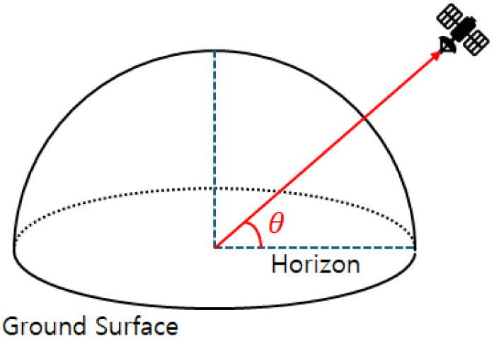
When the position of the ground station in the Earth-Centered Earth-Fixed (ECEF) coordinate system and the position of the satellite in the Earth-Centered Inertial (ECI) coordinate system are known, the satellite elevation at the ground station can be calculated as follows. First, the variables employed in this calculation are defined in Table 16.
TABLE 16.
Definition of variables in the satellite altitude calculation algorithm
The Earth-Centered Earth-Fixed (ECEF) coordinate system is centered at the Earth’s center of mass. In this system, the Z-axis aligns with the Earth’s rotational axis, the X-axis passes through the intersection of the prime meridian and the equatorial plane, and the Y-axis is defined as the cross product of the Z-axis and X-axis.
The Earth-Centered Inertial (ECI) coordinate system is also centered at the Earth’s center of mass, with the Earth’s equatorial plane as the XY-plane. In this system, the X-axis points toward the vernal equinox, the Z-axis is perpendicular to the XY-plane and points toward the North Pole, and the Y-axis is defined as the cross product of the Z-axis and X-axis.
The Earth is assumed to follow the World Geodetic System 1984 (WGS84) ellipsoid model. As shown in Fig. 2, the WGS84 ellipsoid is defined with a semi-major axis of 6,378.1370 km and a semi-minor axis of 6,356.7523 km.
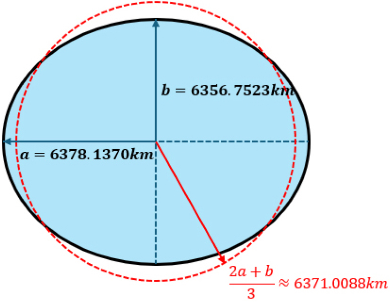
As shown in Fig. 3, to calculate the altitude of a satellite, a line perpendicular to the Earth’s surface must be calculated. Unlike the spherical Earth model, the intersection of the line perpendicular to the Earth’s surface and the XY plane is not the Earth’s center of mass in the WGS84 model.
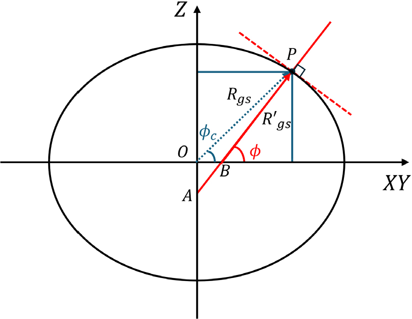
In Fig. 3, the vector OP represents the position vector of the ground station in the ECEF coordinate system. The angle between and the XY-plane is defined as the geocentric latitude.
Let B be the point where a line perpendicular to the ellipsoid meets the XY plane at location P at the ground station, the vector BP is then defined as . The angle 𝜙 between and the XY-plane is referred to as the geodetic latitude.
The relationship between geocentric latitude and geodetic latitude is given as Eq. (1):
The eccentricity () of the ellipsoid can be expressed in terms of the semi-major axis () and semi-minor axis () of the ellipsoid, as shown in Fig. 2, using the following Eq. (2):
As shown in Fig. 4, the position in the ECEF coordinate system can be represented in terms of geocentric latitude () and longitude (𝜓) using the following Eq. (3), (4):
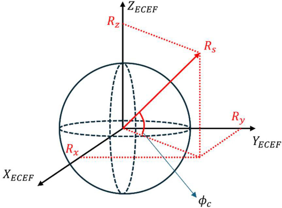
The geodetic latitude and longitude can be calculated using the given position vector of the ground station and the (3)-(4) equations. Based on the calculated geodetic latitude and longitude, the unit vector , which is parallel to the position vector , can be expressed in the ECEF system as Eq. (5):
The satellite elevation is represented in Fig. 5 as angle 𝜃. The relative position vector of the satellite with respect to the ground station can be calculated using Eq. (6). The angle 𝛽 formed between the vectors and , can be computed using Eq. (7).
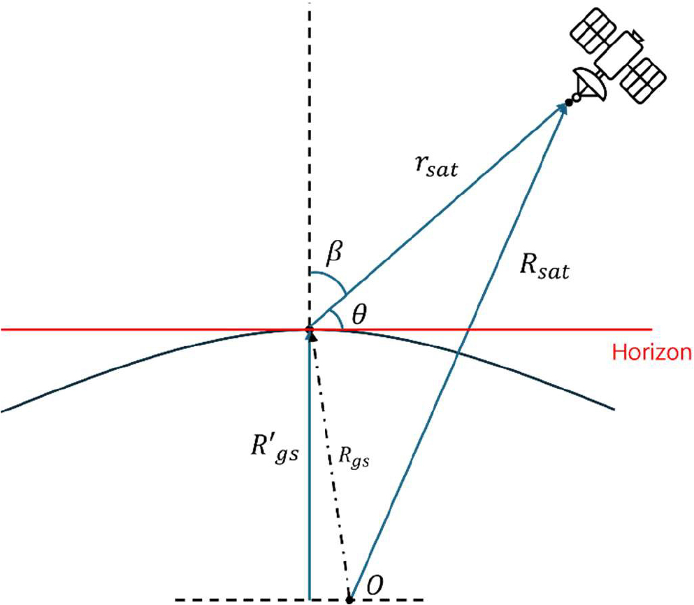
Therefore, the satellite’s elevation angle 𝜃 is calculated as Eq. (8):
Calculating the satellite elevation angle 𝜃 and the satellite’s position vector over time obtained through orbital propagation, the satellite’s revisit time can be numerically computed.
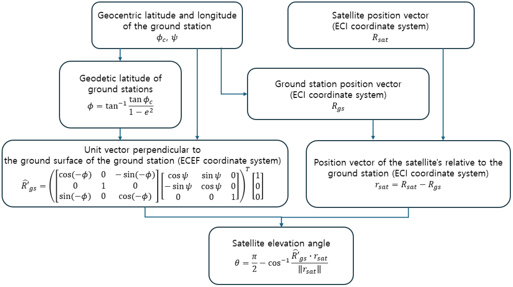
A overview of the above algorithm is presented in Fig. 6.
3. RESULTS AND DISCUSSIONS
The revisit period of national satellites and international satellites over the Korean Peninsula was analyzed. The simulation was conducted over a 24-hour period from 03:00 UTC on June 13, 2024, to 03:00 UTC on June 14, 2024. The location of the ground station was established at 36.3214°N latitude and 127.42°E longitude, with a minimum elevation angle of 5° for a satellite to be considered as having “visited.”
3.1. Analysis of Revisit Periods of National Satellites over the Korean Peninsula
The revisit periods of national satellites over the Korean Peninsula were analyzed for the following satellites: KOMPSAT-3, KOMPSAT-3A, KOMPSAT-5, Next-Generation Medium Satellite-1 (CAS500-1), Next-Generation Small Satellite-2 (NEXTSat-2), and New-space Earth Observation Satellite-1 (NEONSAT-1). In Fig. 7, the X-axis represents time from 12:00 KST on June 13, 2024, to 12:00 KST on June 14, 2024, while the Y-axis lists the satellites. The green lines in each row indicate the times when the respective satellites revisit the Korean Peninsula.
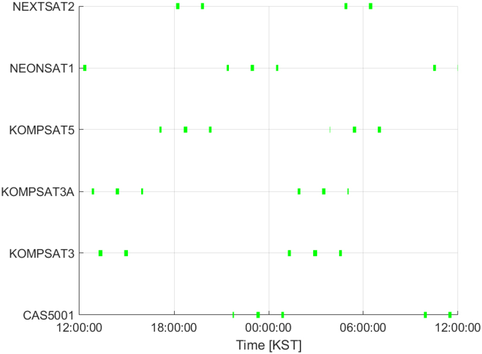
The results demonstrate that each satellite exhibits 2-3 short revisit cycles, followed by an approximately 12-hour gap before the next set of 2-3 short revisits begins. In this report, the group of 2-3 short revisit cycles is defined as a “revisit set”, and the interval between the start of the first revisit in one revisit set and the start of the first revisit in the subsequent revisit set is defined as the “revisit period”.
The total number of revisits, revisit periods, and average revisit times over the 24-hour period are summarized in Table 17.
TABLE 17.
Analysis of the frequency of Korean Peninsula visits by national satellites
3.2. Analysis of Revisit Periods of International Satellites over the Korean Peninsula
From the international satellites investigated in Section 2.2, representative satellite constellations equipped with optical payloads and Synthetic Aperture Radar (SAR) payloads were selected to analyze their revisit periods over the Korean Peninsula. For the EO/IR (Electro-Optical/Infrared) payload constellation, the SkySat constellation operated by Planet Labs (USA) was selected. For the SAR payload constellations, the following systems were selected: the ICEYE-X constellation operated by ICEYE (Finland), the Whitney and Acadia constellations operated by Capella Space (USA), the Umbra constellation operated by Umbra Space (USA), and the QPS-SAR constellation operated by iQPS (Japan).
In the graphs, the X-axis represents the time period from 12:00 KST on June 13, 2024, to 12:00 KST on June 14, 2024, while the Y-axis represents individual satellites within the constellations. The lines in each row indicate the times when the respective satellites revisit the Korean Peninsula.
Additionally, the tables summarize the total number of revisits, revisit periods, and average revisit times over the 24-hour period.
3.2.1. Analysis of the SkySat Constellation’s Revisit Period over the Korean Peninsula
The revisit times of the SkySat constellation over the Korean Peninsula are presented in Fig. 8 and Table 18.
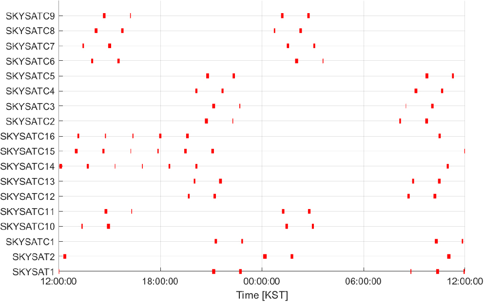
TABLE 18.
Analysis of the frequency of Korean Peninsula visits by Skysat
In the following results, we see that the other satellites, with the exception of SKYSATC 14, 15, and 16, have 2-3 short period visits followed by another short period visit about 12 hours later, similar to the results for the national satellite constellation.
In contrast, SKYSATC-14, 15 and 16 performed 5-6 revisits within a single revisit set. This difference is attributed to their operational orbits, which are low Earth orbits (LEO) with an inclination of approximately 53°, unlike the sun-synchronous orbits (SSO) of other satellites in the constellation.
3.2.2. Analysis of the ICEYE-X Constellation’s Revisit Period over the Korean Peninsula
The revisit times of the ICEYE-X constellation over the Korean Peninsula are presented in Fig. 9 and Table 19. The results indicate that, similar to the national satellite constellations and the SkySat constellation, each satellite in the ICEYE-X constellation showed 2-3 short revisit cycles, followed by an approximate 12-hour gap before the next set of 2-3 short revisit cycles occurred.
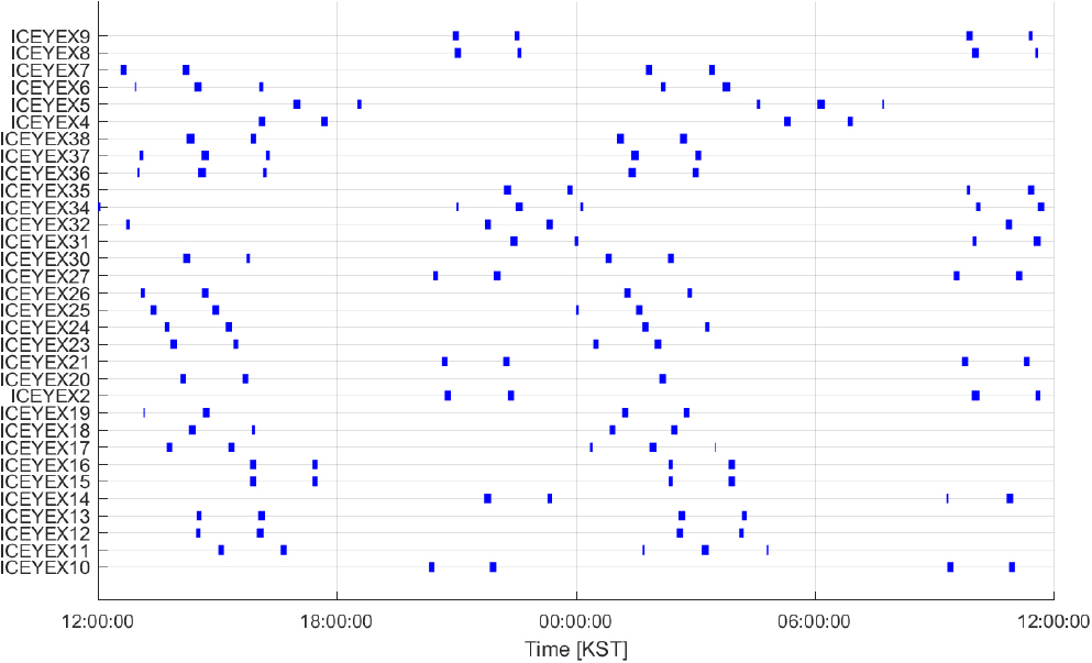
TABLE 19.
Analysis of the frequency of Korean Peninsula visits by ICEYE-X
3.2.3. Analysis of the Capella Constellation’s Revisit Period over the Korean Peninsula
The revisit times of the Whitney and Acadia constellations are presented in Fig. 10 and Table 20.
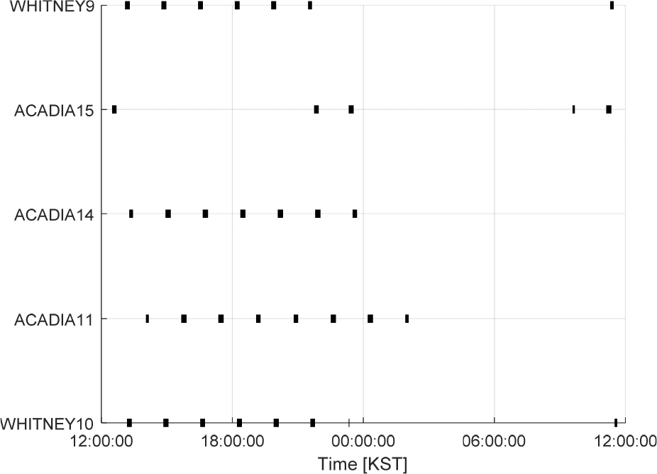
TABLE 20.
Analysis of the frequency of Korean Peninsula visits by Capella’s Constellation
The results show that these satellites show 5 to 8 revisits, demonstrating a significantly higher number of revisits and shorter revisit periods compared to other constellations.
3.2.4. Analysis of the Umbra Constellation’s Revisit Period over the Korean Peninsula
The revisit times of the Umbra constellation over the Korean Peninsula are shown in Fig. 11 and Table 21.
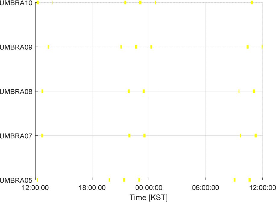
TABLE 21.
Analysis of the frequency of Korean Peninsula visits by Umbra’s Constellation
The results demonstrate that all five satellites revisit the Korean Peninsula 5 to 6 times at approximately 10-hour intervals.
3.2.5. Analysis of the QPS-SAR Satellites’ Revisit Period over the Korean Peninsula
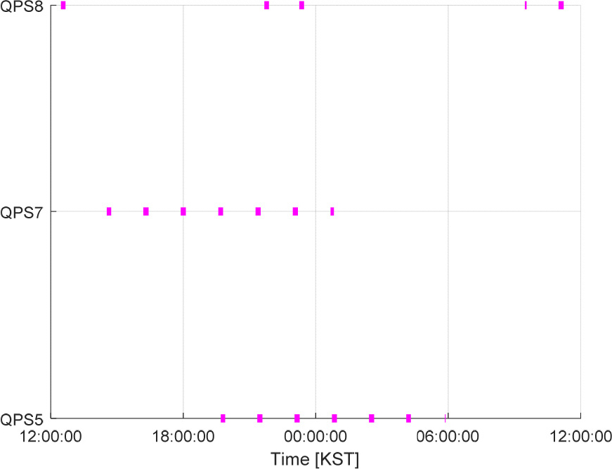
The revisit times of the QPS-SAR satellites over the Korean Peninsula are presented in Fig. 12 and Table 22.
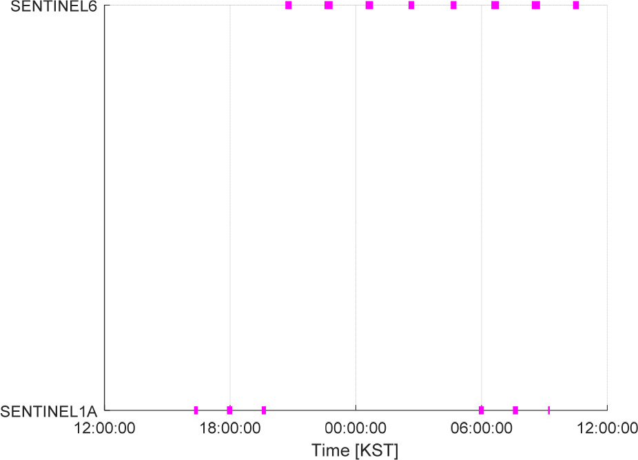
TABLE 22.
Analysis of the frequency of Korean Peninsula visits by QPS-SAR
| Satellite | Number of Visits | Visit Frequency |
Average Visit Duration [s] |
| QPS-SAR 05 | 5 | 10: 47: 27 | 694.8262 |
| QPS-SAR 07 | 7 | 03: 20: 58 | 773.7711 |
| QPS-SAR 08 | 7 | 03: 20: 43 | 669.7044 |
The results indicate that the satellites in the QPS-SAR constellation recorded 5 to 7 revisits over the Korean Peninsula.
3.2.6. Integrated Analysis of Revisit Periods over the Korean Peninsula
The revisit periods of national satellites and international satellites were integrated to analyze the overall revisit patterns over the Korean Peninsula. To account for the limitations of optical payload satellites, which cannot operate during nocturnal periods, revisit times of optical satellites between 18:00 KST and 06:00 KST were excluded from the integrated results. During this period, only the revisit times of SAR- equipped satellites were considered.
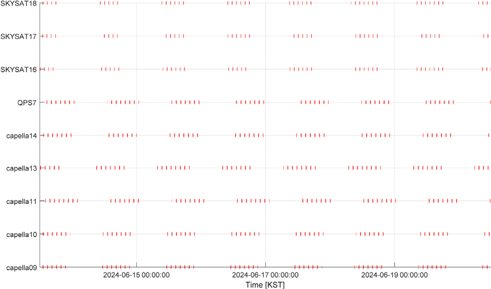
To accommodate satellites operating in non-sun-synchronous orbits, which do not follow the same daily orbital trajectory, revisit times were analyzed over a one-week period from 12:00 KST on June 13 to 12:00 KST on June 20, 2024. The results confirmed that these satellites revisit the Korean Peninsula at comparable time intervals throughout the week, and the analysis is illustrated in Fig. 13.
The integrated analysis combining the results from Sections 3.1 to 3.2 is presented in Fig. 14. In this figure, the X-axis represents the time period from 12:00 KST on June 13, 2024, to 12:00 KST on June 14, 2024, while the Y-axis represents the individual satellites from each constellation: national satellites, SkySat constellation, ICEYE-X constellation, Capella constellation (Whitney and Acadia), Umbra constellation, and QPS-SAR constellation. The colored lines in each row indicate the revisit times for each satellite constellation. Specifically, green lines represent national satellites, blue lines correspond to the ICEYE-X constellation, red lines represent the SkySat constellation, black lines correspond to the Capella constellation, yellow lines represent the Umbra constellation, and pink lines represent the QPS- SAR constellation.
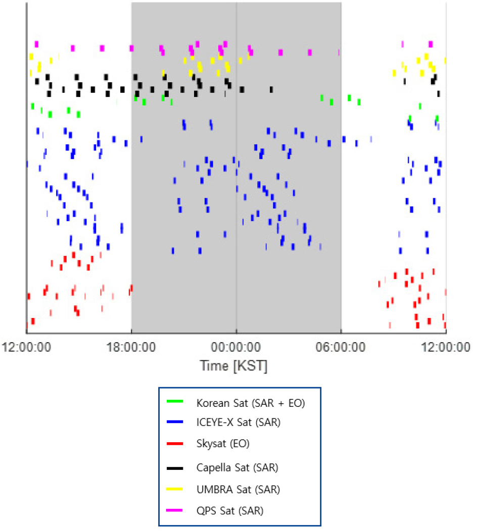
The gray-shaded region in Fig. 14 indicates the nocturnal period, defined as 18:00 KST on June 13 to 06:00 KST on June 14. During this period, optical payload satellites are excluded, and only SAR- equipped satellites’ revisit times are displayed. To facilitate a more direct comparison of the revisit times across all satellite constellations, Fig. 15 consolidates the results from Fig. 14 onto a single row.
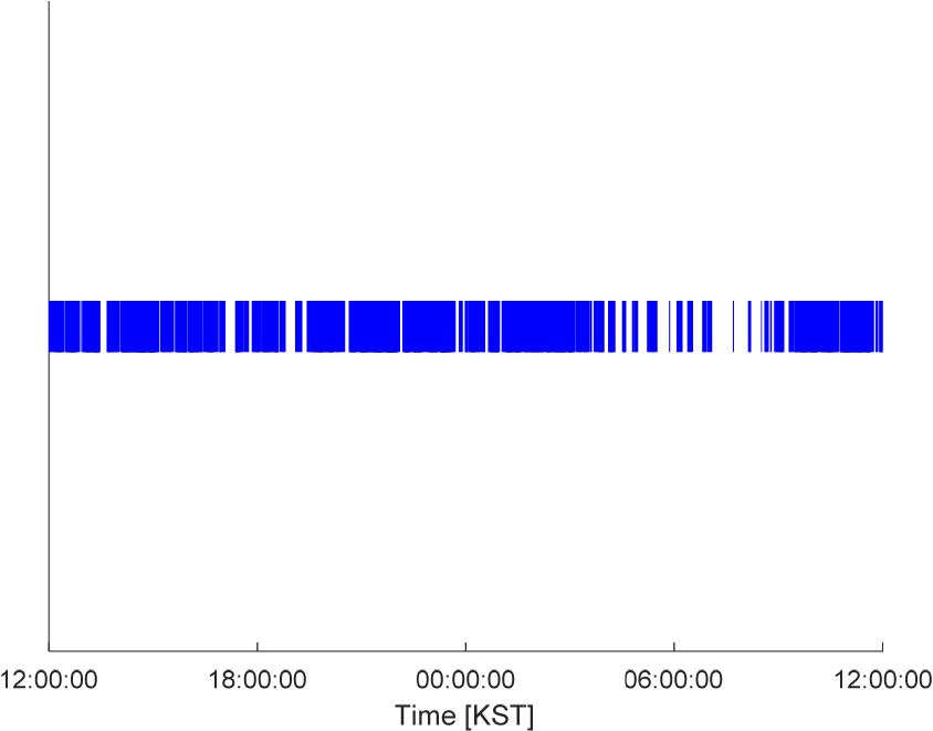
The X-axis of Fig. 15 represents the time period from 12:00 KST on June 13, 2024, to 12:00 KST on June 14, 2024, while the blue lines indicate the revisit times of the national satellite constellation, SkySat constellation, ICEYE-X constellation, Capella constellation (Whitney and Acadia), Umbra constellation, and QPS-SAR constellation over the Korean Peninsula. Analysis revealed that the frequency of satellite revisits experiences a notable decline around 06:00 KST.
To augment revisit frequency around 06:00 KST, we propose supplementing the revisit times with satellites that, although not primarily designed for Earth observation missions, operate in orbits capable of monitoring the Earth at lower imaging resolutions. Specifically, we recommend the inclusion of the Sentinel satellites operated under the Copernicus Program by the European Space Agency (ESA). The orbital characteristics information and specifications for these satellites are summarized in Table 23 [61].
TABLE 23.
Sentinel orbital information and system specifications
The following orbital parameters were applied to the satellite, resulting in the revisit time analysis for the Korean Peninsula shown in Fig. 16. In the case of Sentinel-6, its altitude of approximately 1300 km is unsuitable for acquiring high- resolution imagery compared to other satellites. Therefore, the altitude was adjusted to 700 km for simulation purpose. As a result, as shown in Fig. 17, it was confirm that the result of the Korean Peninsula are possible around 6am.
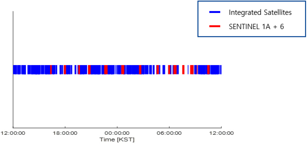
The incorporation of Sentinel satellites would effectively mitigate the reduced revisit frequency observed during the early morning hours, thereby enhancing the comprehensive monitoring capabilities over the Korean Peninsula.
4. CONCLUSIONS
This study has comprehensively investigated the potential for increasing satellite imaging opportunities over the Korean Peninsula through the strategic integration of national and international satellite assets. Our analysis reveals several critical findings that bear significant implications for the advancement of domestic satellite imaging capabilities.
First, the analysis of national satellite revisit patterns demonstrates that current assets exhibit characteristic 2-3 short revisit cycles followed by approximately 12-hour gaps, thereby limiting continuous monitoring capabilities. This temporal distribution necessitates supplementation with international satellite resources to achieve more comprehensive coverage.
Second, the examination of international satellite constellations reveals substantial variations in revisit frequencies and operational characteristics. Notably, the Capella constellation achieves 5-8 daily revisits with significantly shorter revisit periods, whereas traditional sun-synchronous orbit constellations exhibit patterns analogous to national satellites. These findings underscore the potential benefits of incorporating diverse orbital configurations in future national satellite planning.
Third, the integrated analysis identifies a critical gap in satellite coverage around 06:00 KST, which could be effectively addressed through the strategic inclusion of multi-purpose satellites such as the Sentinel constellation. This approach exemplifies the necessity for flexible, adaptive planning systems that can leverage diverse satellite resources.
The technical limitations of the current Multi-Satellite Scheduling System (MSS) highlight the urgent need for advanced optimization algorithms capable of handling increased constellation complexity. As satellite constellations expand exponentially, traditional optimization methods become increasingly inadequate, thereby necessitating the implementation of artificial intelligence and machine learning approaches as demonstrated in international best practices.
From an institutional perspective, the study emphasizes the critical importance of establishing robust international cooperation frameworks and data-sharing protocols. The successful implementation of integrated satellite imaging systems requires not merely technical solutions but also diplomatic initiatives and policy reforms that facilitate cross-border collaboration while maintaining national security interests.
Looking forward, the development of integrated satellite imaging systems represents a crucial step toward enhancing South Korea’s Earth observation capabilities. The recommendations presented herein—including the adoption of advanced scheduling algorithms, expansion of ground station infrastructure, and establishment of international partnerships—provide a roadmap for achieving comprehensive, near-real-time monitoring of the Korean Peninsula.
In conclusion, this study establishes the technical and operational foundation for maximizing satellite imaging opportunities through integrated multi-satellite systems. The successful implementation of these recommendations will significantly enhance South Korea’s capabilities in environmental monitoring, disaster response, and national security applications, thereby positioning the nation at the forefront of satellite-based Earth observation technology.

